

EDG Tour Große Schwerter Runde + K2
A cycling route starting in Dortmund, North Rhine-Westphalia, Germany.
Overview
About this route
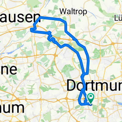
Die Tour führt von der Bittermark längsüber das Ardeygebirge bis zu äußersten Spitze Dortmunds.
Sie bedient vorallem die Vorlieben der racelastig orientierten HT-Fahrer. Berg auf gehts meist auf den Hauptwegen Bergab kann entweder richtig Tempo gemacht werden, oder man muss sich durch enge Trails schlängeln.
- -:--
- Duration
- 56.2 km
- Distance
- 693 m
- Ascent
- 693 m
- Descent
- ---
- Avg. speed
- ---
- Max. altitude
Route quality
Waytypes & surfaces along the route
Waytypes
Track
20.5 km
(36 %)
Path
20 km
(36 %)
Surfaces
Paved
13.4 km
(24 %)
Unpaved
33.7 km
(60 %)
Gravel
18.6 km
(33 %)
Asphalt
13 km
(23 %)
Continue with Bikemap
Use, edit, or download this cycling route
You would like to ride EDG Tour Große Schwerter Runde + K2 or customize it for your own trip? Here is what you can do with this Bikemap route:
Free features
- Save this route as favorite or in collections
- Copy & plan your own version of this route
- Sync your route with Garmin or Wahoo
Premium features
Free trial for 3 days, or one-time payment. More about Bikemap Premium.
- Navigate this route on iOS & Android
- Export a GPX / KML file of this route
- Create your custom printout (try it for free)
- Download this route for offline navigation
Discover more Premium features.
Get Bikemap PremiumFrom our community
Other popular routes starting in Dortmund
 Wellinghofer RTF 75km-Strecke
- Distance
- 79.8 km
- Ascent
- 447 m
- Descent
- 444 m
- Location
- Dortmund, North Rhine-Westphalia, Germany
 Rund um den Dortmunder Süden
- Distance
- 61.4 km
- Ascent
- 313 m
- Descent
- 313 m
- Location
- Dortmund, North Rhine-Westphalia, Germany
 Emscherradweg bis Rhein Herne Kanal
- Distance
- 49.6 km
- Ascent
- 114 m
- Descent
- 113 m
- Location
- Dortmund, North Rhine-Westphalia, Germany
 Hoerde Hohensyburg
- Distance
- 40.8 km
- Ascent
- 328 m
- Descent
- 328 m
- Location
- Dortmund, North Rhine-Westphalia, Germany
 Wellinghofer RTF 41km-Strecke
- Distance
- 39.2 km
- Ascent
- 309 m
- Descent
- 309 m
- Location
- Dortmund, North Rhine-Westphalia, Germany
 Dortmund-Emscherquelle-Kamen-Dortmund
- Distance
- 67.3 km
- Ascent
- 213 m
- Descent
- 206 m
- Location
- Dortmund, North Rhine-Westphalia, Germany
 Dortmund-Süd, Route 3 von 5
- Distance
- 25.9 km
- Ascent
- 300 m
- Descent
- 297 m
- Location
- Dortmund, North Rhine-Westphalia, Germany
 Wambel - Hohensyburg
- Distance
- 18 km
- Ascent
- 0 m
- Descent
- 0 m
- Location
- Dortmund, North Rhine-Westphalia, Germany
Open it in the app