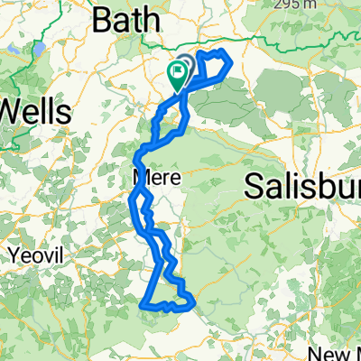
FRide 10th May
A cycling route starting in Westbury, England, United Kingdom.
Overview
About this route
Undulating first third then flat! Â Â
- -:--
- Duration
- 52 km
- Distance
- 156 m
- Ascent
- 165 m
- Descent
- ---
- Avg. speed
- ---
- Max. altitude
Route quality
Waytypes & surfaces along the route
Waytypes
Busy road
18.2 km
(35 %)
Quiet road
16.1 km
(31 %)
Surfaces
Paved
18 km
(35 %)
Unpaved
0.8 km
(1 %)
Asphalt
17.7 km
(34 %)
Unpaved (undefined)
0.8 km
(1 %)
Continue with Bikemap
Use, edit, or download this cycling route
You would like to ride FRide 10th May or customize it for your own trip? Here is what you can do with this Bikemap route:
Free features
- Save this route as favorite or in collections
- Copy & plan your own version of this route
- Sync your route with Garmin or Wahoo
Premium features
Free trial for 3 days, or one-time payment. More about Bikemap Premium.
- Navigate this route on iOS & Android
- Export a GPX / KML file of this route
- Create your custom printout (try it for free)
- Download this route for offline navigation
Discover more Premium features.
Get Bikemap PremiumFrom our community
Other popular routes starting in Westbury
- FRide 10th May
- Distance
- 52 km
- Ascent
- 156 m
- Descent
- 165 m
- Location
- Westbury, England, United Kingdom
- 3day ride devon
- Distance
- 355.8 km
- Ascent
- 1,292 m
- Descent
- 1,294 m
- Location
- Westbury, England, United Kingdom
- 15/04
- Distance
- 14.9 km
- Ascent
- 85 m
- Descent
- 116 m
- Location
- Westbury, England, United Kingdom
- Timor Road 53 to Timor Road 53
- Distance
- 8.5 km
- Ascent
- 76 m
- Descent
- 69 m
- Location
- Westbury, England, United Kingdom
- mber Range Perimeter Path.gpx
- Distance
- 47.5 km
- Ascent
- 520 m
- Descent
- 528 m
- Location
- Westbury, England, United Kingdom
- blandford2
- Distance
- 175.2 km
- Ascent
- 709 m
- Descent
- 700 m
- Location
- Westbury, England, United Kingdom
- Social ride June
- Distance
- 46.4 km
- Ascent
- 263 m
- Descent
- 267 m
- Location
- Westbury, England, United Kingdom
- Warminster Road, Westbury to Michaelstone Road, Cardiff
- Distance
- 126.6 km
- Ascent
- 1,099 m
- Descent
- 1,109 m
- Location
- Westbury, England, United Kingdom
Open it in the app