

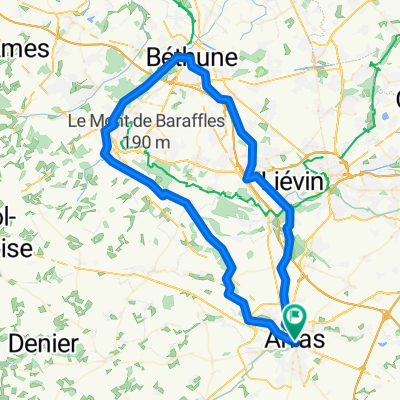
Arras - Heuchin
A cycling route starting in Arras, Hauts-de-France, France.
Overview
About this route
Planning a route from the Train station to the country house
- -:--
- Duration
- 48.7 km
- Distance
- 235 m
- Ascent
- 220 m
- Descent
- ---
- Avg. speed
- ---
- Max. altitude
Route quality
Waytypes & surfaces along the route
Waytypes
Road
7.8 km
(16 %)
Quiet road
5.8 km
(12 %)
Surfaces
Paved
7.8 km
(16 %)
Unpaved
3.9 km
(8 %)
Asphalt
7.8 km
(16 %)
Gravel
2.9 km
(6 %)
Continue with Bikemap
Use, edit, or download this cycling route
You would like to ride Arras - Heuchin or customize it for your own trip? Here is what you can do with this Bikemap route:
Free features
- Save this route as favorite or in collections
- Copy & plan your own version of this route
- Sync your route with Garmin or Wahoo
Premium features
Free trial for 3 days, or one-time payment. More about Bikemap Premium.
- Navigate this route on iOS & Android
- Export a GPX / KML file of this route
- Create your custom printout (try it for free)
- Download this route for offline navigation
Discover more Premium features.
Get Bikemap PremiumFrom our community
Other popular routes starting in Arras
 fr7-arras_bapaume
- Distance
- 27.3 km
- Ascent
- 178 m
- Descent
- 119 m
- Location
- Arras, Hauts-de-France, France
 PaDag3
- Distance
- 124.6 km
- Ascent
- 462 m
- Descent
- 429 m
- Location
- Arras, Hauts-de-France, France
 Arras Béthune
- Distance
- 80.9 km
- Ascent
- 345 m
- Descent
- 346 m
- Location
- Arras, Hauts-de-France, France
 Arras to Albert
- Distance
- 40.2 km
- Ascent
- 214 m
- Descent
- 212 m
- Location
- Arras, Hauts-de-France, France
 Untitled route
- Distance
- 127.1 km
- Ascent
- 592 m
- Descent
- 626 m
- Location
- Arras, Hauts-de-France, France
 Day 3 Arras - Compiegne
- Distance
- 129.4 km
- Ascent
- 338 m
- Descent
- 378 m
- Location
- Arras, Hauts-de-France, France
 Day 20 - Arras - Hardecourt-aux-Bois
- Distance
- 65.1 km
- Ascent
- 485 m
- Descent
- 457 m
- Location
- Arras, Hauts-de-France, France
 From Arras to Monchy-le-Preux
- Distance
- 44.8 km
- Ascent
- 209 m
- Descent
- 181 m
- Location
- Arras, Hauts-de-France, France
Open it in the app