

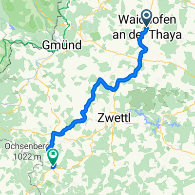
Teiche-Radroute
A cycling route starting in Waidhofen an der Thaya, Lower Austria, Austria.
Overview
About this route
- -:--
- Duration
- 52.9 km
- Distance
- 288 m
- Ascent
- 285 m
- Descent
- ---
- Avg. speed
- ---
- Max. altitude
Route quality
Waytypes & surfaces along the route
Waytypes
Quiet road
20.2 km
(38 %)
Road
14.1 km
(27 %)
Surfaces
Paved
30.5 km
(58 %)
Unpaved
0.8 km
(1 %)
Asphalt
25.9 km
(49 %)
Paved (undefined)
4.6 km
(9 %)
Continue with Bikemap
Use, edit, or download this cycling route
You would like to ride Teiche-Radroute or customize it for your own trip? Here is what you can do with this Bikemap route:
Free features
- Save this route as favorite or in collections
- Copy & plan your own version of this route
- Sync your route with Garmin or Wahoo
Premium features
Free trial for 3 days, or one-time payment. More about Bikemap Premium.
- Navigate this route on iOS & Android
- Export a GPX / KML file of this route
- Create your custom printout (try it for free)
- Download this route for offline navigation
Discover more Premium features.
Get Bikemap PremiumFrom our community
Other popular routes starting in Waidhofen an der Thaya
 Waidhofen an d. Thaya nach Zwettl Rundweg 67 km
- Distance
- 66.9 km
- Ascent
- 464 m
- Descent
- 473 m
- Location
- Waidhofen an der Thaya, Lower Austria, Austria
 Route Radrunde Waidhofen
- Distance
- 17.5 km
- Ascent
- 258 m
- Descent
- 257 m
- Location
- Waidhofen an der Thaya, Lower Austria, Austria
 Waidhofen - Arbesbach
- Distance
- 63.2 km
- Ascent
- 1,007 m
- Descent
- 715 m
- Location
- Waidhofen an der Thaya, Lower Austria, Austria
 Waidhofen Vestenötting Meires
- Distance
- 20.3 km
- Ascent
- 205 m
- Descent
- 203 m
- Location
- Waidhofen an der Thaya, Lower Austria, Austria
 17.April 2.3
- Distance
- 31.2 km
- Ascent
- 270 m
- Descent
- 256 m
- Location
- Waidhofen an der Thaya, Lower Austria, Austria
 Waidhofen -Richtung Westen nach Gmünd und retour, 72 km
- Distance
- 73.3 km
- Ascent
- 419 m
- Descent
- 408 m
- Location
- Waidhofen an der Thaya, Lower Austria, Austria
 17.April 2.3
- Distance
- 36.8 km
- Ascent
- 303 m
- Descent
- 302 m
- Location
- Waidhofen an der Thaya, Lower Austria, Austria
 4. Radwandertag RLH Waidhofen/Th
- Distance
- 19.4 km
- Ascent
- 126 m
- Descent
- 128 m
- Location
- Waidhofen an der Thaya, Lower Austria, Austria
Open it in the app