

Neckartal Nord
A cycling route starting in Stuttgart Mühlhausen, Baden-Wurttemberg, Germany.
Overview
About this route
- -:--
- Duration
- 52.2 km
- Distance
- 175 m
- Ascent
- 214 m
- Descent
- ---
- Avg. speed
- ---
- Max. altitude

Route quality
Waytypes & surfaces along the route
Waytypes
Track
16.2 km
(31 %)
Quiet road
13.6 km
(26 %)
Surfaces
Paved
49.1 km
(94 %)
Unpaved
1.6 km
(3 %)
Asphalt
48 km
(92 %)
Concrete
1 km
(2 %)
Continue with Bikemap
Use, edit, or download this cycling route
You would like to ride Neckartal Nord or customize it for your own trip? Here is what you can do with this Bikemap route:
Free features
- Save this route as favorite or in collections
- Copy & plan your own version of this route
- Sync your route with Garmin or Wahoo
Premium features
Free trial for 3 days, or one-time payment. More about Bikemap Premium.
- Navigate this route on iOS & Android
- Export a GPX / KML file of this route
- Create your custom printout (try it for free)
- Download this route for offline navigation
Discover more Premium features.
Get Bikemap PremiumFrom our community
Other popular routes starting in Stuttgart Mühlhausen
 Robinson To Patch Barracks
- Distance
- 18 km
- Ascent
- 340 m
- Descent
- 198 m
- Location
- Stuttgart Mühlhausen, Baden-Wurttemberg, Germany
 RTF Rund um Stuttgart
- Distance
- 162.4 km
- Ascent
- 875 m
- Descent
- 871 m
- Location
- Stuttgart Mühlhausen, Baden-Wurttemberg, Germany
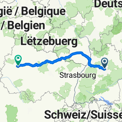 18.09.25: Von Fellbach bis Châlons-en-Champagne (Bahn, BB Hotel)
- Distance
- 504.8 km
- Ascent
- 4,621 m
- Descent
- 4,819 m
- Location
- Stuttgart Mühlhausen, Baden-Wurttemberg, Germany
 Neckartal Nord
- Distance
- 52.2 km
- Ascent
- 175 m
- Descent
- 214 m
- Location
- Stuttgart Mühlhausen, Baden-Wurttemberg, Germany
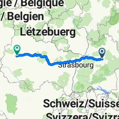 Von Oeffingen bis Châlons-en-Champagne
- Distance
- 471.3 km
- Ascent
- 3,247 m
- Descent
- 3,444 m
- Location
- Stuttgart Mühlhausen, Baden-Wurttemberg, Germany
 Steinahldenfeld -> Bärensee (40km)
- Distance
- 43.3 km
- Ascent
- 438 m
- Descent
- 439 m
- Location
- Stuttgart Mühlhausen, Baden-Wurttemberg, Germany
 Robinson To Patch Barracks
- Distance
- 18 km
- Ascent
- 339 m
- Descent
- 194 m
- Location
- Stuttgart Mühlhausen, Baden-Wurttemberg, Germany
 Remseck - Remstal - Filstal - Schw. Alb
- Distance
- 142.2 km
- Ascent
- 1,893 m
- Descent
- 1,843 m
- Location
- Stuttgart Mühlhausen, Baden-Wurttemberg, Germany
Open it in the app