

Alejandro Quesada-Sabanilla
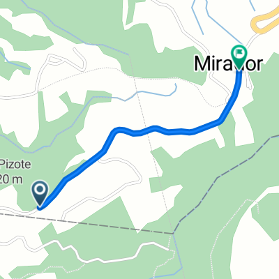
A cycling route starting in Concepción, Cartago Province, Costa Rica.
Overview
About this route
- 30 min
- Duration
- 6.3 km
- Distance
- 171 m
- Ascent
- 289 m
- Descent
- 12.6 km/h
- Avg. speed
- ---
- Max. altitude

Route quality
Waytypes & surfaces along the route
Waytypes
Quiet road
1.5 km
(24 %)
Road
0.7 km
(11 %)
Undefined
4.1 km
(65 %)
Surfaces
Paved
5.6 km
(89 %)
Asphalt
5 km
(79 %)
Paved (undefined)
0.6 km
(10 %)
Undefined
0.7 km
(11 %)
Continue with Bikemap
Use, edit, or download this cycling route
You would like to ride Alejandro Quesada-Sabanilla or customize it for your own trip? Here is what you can do with this Bikemap route:
Free features
- Save this route as favorite or in collections
- Copy & plan your own version of this route
- Sync your route with Garmin or Wahoo
Premium features
Free trial for 3 days, or one-time payment. More about Bikemap Premium.
- Navigate this route on iOS & Android
- Export a GPX / KML file of this route
- Create your custom printout (try it for free)
- Download this route for offline navigation
Discover more Premium features.
Get Bikemap PremiumFrom our community
Other popular routes starting in Concepción
 Alejandro Quesada-Sabanilla
- Distance
- 6.3 km
- Ascent
- 171 m
- Descent
- 289 m
- Location
- Concepción, Cartago Province, Costa Rica
 De Calle El Poró, Concepción a Los Guido
- Distance
- 15.4 km
- Ascent
- 131 m
- Descent
- 296 m
- Location
- Concepción, Cartago Province, Costa Rica
 De Ruta Nacional Secundaria 218 a 214, San Miguel
- Distance
- 28 km
- Ascent
- 142 m
- Descent
- 990 m
- Location
- Concepción, Cartago Province, Costa Rica
 Von San Rafael bis Rancho Redondo
- Distance
- 1.7 km
- Ascent
- 240 m
- Descent
- 15 m
- Location
- Concepción, Cartago Province, Costa Rica
 Vía 306, San José a Calle Yerbabuena, San José
- Distance
- 6.7 km
- Ascent
- 187 m
- Descent
- 135 m
- Location
- Concepción, Cartago Province, Costa Rica
 Hueviado
- Distance
- 21 km
- Ascent
- 642 m
- Descent
- 662 m
- Location
- Concepción, Cartago Province, Costa Rica
 De W2M3+H5R, Concepción a Calle al Hogar, Guácimo
- Distance
- 106.1 km
- Ascent
- 2,806 m
- Descent
- 4,076 m
- Location
- Concepción, Cartago Province, Costa Rica
 Avenida Uno, San José a Avenida Uno, San José
- Distance
- 17.2 km
- Ascent
- 260 m
- Descent
- 259 m
- Location
- Concepción, Cartago Province, Costa Rica
Open it in the app