- 55.5 km
- 150 m
- 152 m
- Neuburg, Rhineland-Palatinate, Germany
Rechts und links des Rheins
A cycling route starting in Neuburg, Rhineland-Palatinate, Germany.
Overview
About this route
South of Karlsruhe and north of Strasbourg, this tour leads to the Rhine on both the French and German sides. Naturally, the route is completely flat, and even less experienced cyclists can easily manage this nearly 60 km ride. However, there is often a noticeable wind blowing upstream, meaning headwind heading north. The starting point chosen was the ferry dock in Neuburgweier; the ferry first takes you to the other side of the Rhine. A few kilometers still go through Rhineland-Palatinate before you travel - almost always along the river - through Alsace. Crossing the Rhine bridge at Iffezheim, you return to Baden-Württemberg and can get back to the starting point via the numerous bike paths through the riparian forests or the lightly trafficked side roads through the Rhine villages.
- -:--
- Duration
- 54.2 km
- Distance
- 35 m
- Ascent
- 32 m
- Descent
- ---
- Avg. speed
- ---
- Max. altitude
created this 18 years ago
Continue with Bikemap
Use, edit, or download this cycling route
You would like to ride Rechts und links des Rheins or customize it for your own trip? Here is what you can do with this Bikemap route:
Free features
- Save this route as favorite or in collections
- Copy & plan your own version of this route
- Sync your route with Garmin or Wahoo
Premium features
Free trial for 3 days, or one-time payment. More about Bikemap Premium.
- Navigate this route on iOS & Android
- Export a GPX / KML file of this route
- Create your custom printout (try it for free)
- Download this route for offline navigation
Discover more Premium features.
Get Bikemap PremiumFrom our community
Other popular routes starting in Neuburg
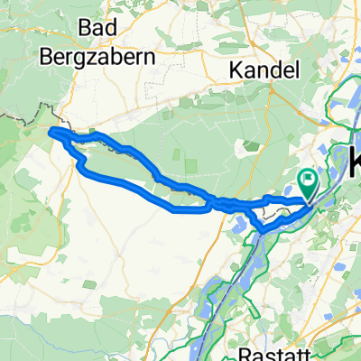
- Route Neuburg am Rhein nach Weißenburg und zurüvck
- mit dem Rennrad -- abseits des Verkehrs -- durch die Dörfer des nördlichen Elsaß
- 230.1 km
- 328 m
- 327 m
- Neuburg, Rhineland-Palatinate, Germany
- RR Rheinstetten - Hornisgrinde und zurück
- 140.2 km
- 1,124 m
- 1,124 m
- Neuburg, Rhineland-Palatinate, Germany
- Rechts und links des Rheins
- 54.2 km
- 35 m
- 32 m
- Neuburg, Rhineland-Palatinate, Germany
- nach Freiburg über Rastatt - Renchen - die badische Weinstraße nach Gengenbach - ins Kinzigtal bis Haslach - nach Hofstetten über den Salmenbusch nach Elzach d
- 166.9 km
- 914 m
- 739 m
- Neuburg, Rhineland-Palatinate, Germany
- FR1-01_Neuburg - Eppenbrunn_71,7km 520hm
- 71.7 km
- 1,348 m
- 1,161 m
- Neuburg, Rhineland-Palatinate, Germany
- Rheinradweg_Ostroute
- 333.6 km
- 368 m
- 405 m
- Neuburg, Rhineland-Palatinate, Germany
- Bienwaldtour20210227
- 35.7 km
- 36 m
- 39 m
- Neuburg, Rhineland-Palatinate, Germany
Open it in the app


