

B2B00324 55014>55413 via Lexington, Co Rd C, Minneapolis Diagonal Trail
A cycling route starting in Circle Pines, Minnesota, United States.
Overview
About this route
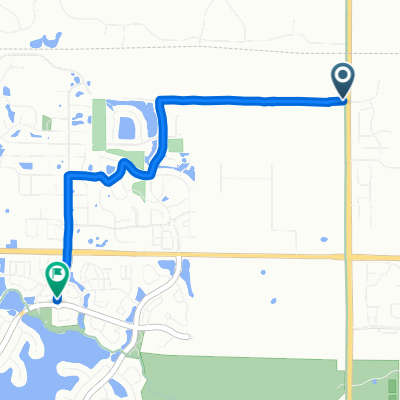
Lexington and County Rd C have a bike path along the road. Walnut street leads to the Minneapolis Diagonal Trail.
- -:--
- Duration
- 25.2 km
- Distance
- 66 m
- Ascent
- 60 m
- Descent
- ---
- Avg. speed
- 304 m
- Max. altitude
Route quality
Waytypes & surfaces along the route
Waytypes
Cycleway
14.1 km
(56 %)
Quiet road
2 km
(8 %)
Surfaces
Paved
19.1 km
(76 %)
Asphalt
12.8 km
(51 %)
Paved (undefined)
5.5 km
(22 %)
Continue with Bikemap
Use, edit, or download this cycling route
You would like to ride B2B00324 55014>55413 via Lexington, Co Rd C, Minneapolis Diagonal Trail or customize it for your own trip? Here is what you can do with this Bikemap route:
Free features
- Save this route as favorite or in collections
- Copy & plan your own version of this route
- Sync your route with Garmin or Wahoo
Premium features
Free trial for 3 days, or one-time payment. More about Bikemap Premium.
- Navigate this route on iOS & Android
- Export a GPX / KML file of this route
- Create your custom printout (try it for free)
- Download this route for offline navigation
Discover more Premium features.
Get Bikemap PremiumFrom our community
Other popular routes starting in Circle Pines
 202 Elm St, Lino Lakes to 628–630 Town Center Pkwy, Lino Lakes
- Distance
- 5 km
- Ascent
- 30 m
- Descent
- 35 m
- Location
- Circle Pines, Minnesota, United States
 Rice Creek Chain all paved trails & 2 off trails
- Distance
- 10.4 km
- Ascent
- 42 m
- Descent
- 43 m
- Location
- Circle Pines, Minnesota, United States
 Steady ride in Lino Lakes
- Distance
- 26.4 km
- Ascent
- 60 m
- Descent
- 59 m
- Location
- Circle Pines, Minnesota, United States
 B2B00324 55014>55413 via Lexington, Co Rd C, Minneapolis Diagonal Trail
- Distance
- 25.2 km
- Ascent
- 66 m
- Descent
- 60 m
- Location
- Circle Pines, Minnesota, United States
 Directions to Shaorn's home
- Distance
- 40.8 km
- Ascent
- 233 m
- Descent
- 219 m
- Location
- Circle Pines, Minnesota, United States
 4101 131st Ave NE, Blaine to 12283 Flanders St NE, Blaine
- Distance
- 3.9 km
- Ascent
- 6 m
- Descent
- 10 m
- Location
- Circle Pines, Minnesota, United States
 Blaine to 6492 Tomahawk Trail, Lino Lakes
- Distance
- 3.7 km
- Ascent
- 21 m
- Descent
- 24 m
- Location
- Circle Pines, Minnesota, United States
 B2B00390 55126>55344 viaHodgson/Victoria/Como/Intercampus/4thSE/StoneArch/CedarTrail/Hopkins/ShadyOak
- Distance
- 51.7 km
- Ascent
- 154 m
- Descent
- 160 m
- Location
- Circle Pines, Minnesota, United States
Open it in the app