

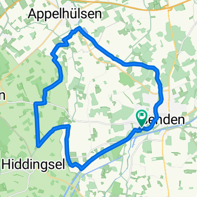
Schlösser Tour im südlichen Münsterland
A cycling route starting in Senden, North Rhine-Westphalia, Germany.
Overview
About this route
Ideale Tour für ein Wochenende im Münsterland.
- -:--
- Duration
- 133.8 km
- Distance
- 320 m
- Ascent
- 319 m
- Descent
- ---
- Avg. speed
- 115 m
- Max. altitude
Route quality
Waytypes & surfaces along the route
Waytypes
Quiet road
72.8 km
(54 %)
Path
21 km
(16 %)
Surfaces
Paved
119.8 km
(89 %)
Unpaved
10.5 km
(8 %)
Asphalt
108.1 km
(81 %)
Paving stones
10.9 km
(8 %)
Continue with Bikemap
Use, edit, or download this cycling route
You would like to ride Schlösser Tour im südlichen Münsterland or customize it for your own trip? Here is what you can do with this Bikemap route:
Free features
- Save this route as favorite or in collections
- Copy & plan your own version of this route
- Split it into stages to create a multi-day tour
- Sync your route with Garmin or Wahoo
Premium features
Free trial for 3 days, or one-time payment. More about Bikemap Premium.
- Navigate this route on iOS & Android
- Export a GPX / KML file of this route
- Create your custom printout (try it for free)
- Download this route for offline navigation
Discover more Premium features.
Get Bikemap PremiumFrom our community
Other popular routes starting in Senden
 Route nach De Moer
- Distance
- 68.6 km
- Ascent
- 385 m
- Descent
- 350 m
- Location
- Senden, North Rhine-Westphalia, Germany
 pättkestour westl. senden
- Distance
- 22.5 km
- Ascent
- 60 m
- Descent
- 60 m
- Location
- Senden, North Rhine-Westphalia, Germany
 Brahmsweg nach L832
- Distance
- 68.1 km
- Ascent
- 171 m
- Descent
- 164 m
- Location
- Senden, North Rhine-Westphalia, Germany
 Bösensell - Senden
- Distance
- 28.2 km
- Ascent
- 106 m
- Descent
- 112 m
- Location
- Senden, North Rhine-Westphalia, Germany
 Samstag, Senden-Davensberg-Nordkirchen-Lüdinghausen-Senden
- Distance
- 63 km
- Ascent
- 156 m
- Descent
- 157 m
- Location
- Senden, North Rhine-Westphalia, Germany
 CE110916
- Distance
- 22.8 km
- Ascent
- 39 m
- Descent
- 37 m
- Location
- Senden, North Rhine-Westphalia, Germany
 Am Dorn nach Drensteinfurt
- Distance
- 29.1 km
- Ascent
- 68 m
- Descent
- 68 m
- Location
- Senden, North Rhine-Westphalia, Germany
 Schlösser Tour im südlichen Münsterland
- Distance
- 133.8 km
- Ascent
- 320 m
- Descent
- 319 m
- Location
- Senden, North Rhine-Westphalia, Germany
Open it in the app