

Bellheim-Fähre Leimersheim
A cycling route starting in Bellheim, Rhineland-Palatinate, Germany.
Overview
About this route
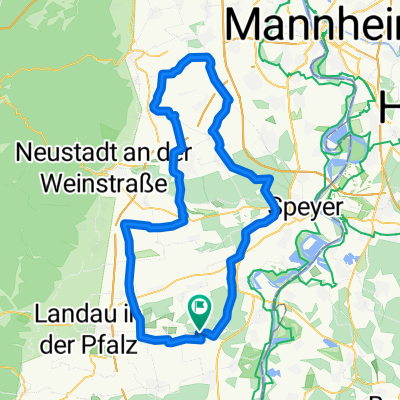
Bellheim over forest paths and the Rhine dam to the ferry Leimersheim
Will be extended to a 2-day trip
- -:--
- Duration
- 16.2 km
- Distance
- 56 m
- Ascent
- 67 m
- Descent
- ---
- Avg. speed
- ---
- Max. altitude
Route quality
Waytypes & surfaces along the route
Waytypes
Track
11.5 km
(71 %)
Cycleway
1.6 km
(10 %)
Surfaces
Paved
14.1 km
(87 %)
Unpaved
1.9 km
(12 %)
Asphalt
14.1 km
(87 %)
Ground
1.6 km
(10 %)
Continue with Bikemap
Use, edit, or download this cycling route
You would like to ride Bellheim-Fähre Leimersheim or customize it for your own trip? Here is what you can do with this Bikemap route:
Free features
- Save this route as favorite or in collections
- Copy & plan your own version of this route
- Sync your route with Garmin or Wahoo
Premium features
Free trial for 3 days, or one-time payment. More about Bikemap Premium.
- Navigate this route on iOS & Android
- Export a GPX / KML file of this route
- Create your custom printout (try it for free)
- Download this route for offline navigation
Discover more Premium features.
Get Bikemap PremiumFrom our community
Other popular routes starting in Bellheim
 Bellheim-Insheim-Kandel-Bellheim
- Distance
- 51.9 km
- Ascent
- 122 m
- Descent
- 122 m
- Location
- Bellheim, Rhineland-Palatinate, Germany
 Bellheim-Hertlingshausen (Naturfreunde-Haus)
- Distance
- 128.4 km
- Ascent
- 365 m
- Descent
- 362 m
- Location
- Bellheim, Rhineland-Palatinate, Germany
 Radtour 2016 Etappe 1
- Distance
- 119.8 km
- Ascent
- 123 m
- Descent
- 126 m
- Location
- Bellheim, Rhineland-Palatinate, Germany
 Rund um Landau
- Distance
- 39 km
- Ascent
- 180 m
- Descent
- 169 m
- Location
- Bellheim, Rhineland-Palatinate, Germany
 Berghausen, Angelsportverein
- Distance
- 21 km
- Ascent
- 58 m
- Descent
- 80 m
- Location
- Bellheim, Rhineland-Palatinate, Germany
 Von Bellheim nach Hambacher Schloß
- Distance
- 25.6 km
- Ascent
- 125 m
- Descent
- 97 m
- Location
- Bellheim, Rhineland-Palatinate, Germany
 Bellheim- Hochstadt- Vennigen. Hüttenbrun- Rhodt- Walsheim- Offenbach- Ottersheim
- Distance
- 53.6 km
- Ascent
- 296 m
- Descent
- 291 m
- Location
- Bellheim, Rhineland-Palatinate, Germany
 Radtour 2016 Etappe 2
- Distance
- 95 km
- Ascent
- 115 m
- Descent
- 118 m
- Location
- Bellheim, Rhineland-Palatinate, Germany
Open it in the app