
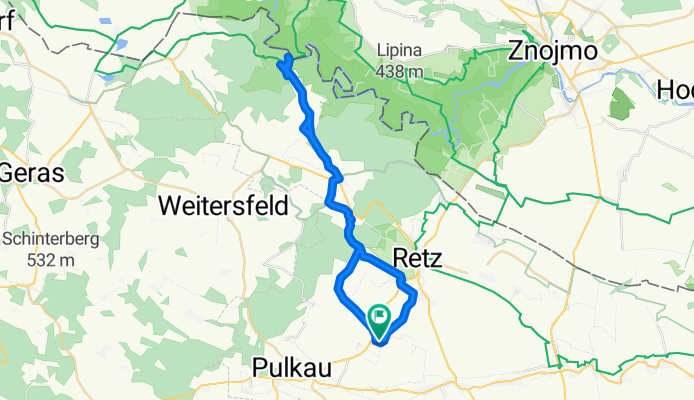
Pillersdorf - Obernalb-Hofern-Hardegg-Obermarkersdorf - Pillersdorf
A cycling route starting in Schrattenthal, Lower Austria, Austria.
Overview
About this route
- -:--
- Duration
- 39.9 km
- Distance
- 488 m
- Ascent
- 488 m
- Descent
- ---
- Avg. speed
- ---
- Max. altitude
Route quality
Waytypes & surfaces along the route
Waytypes
Road
10.8 km
(27 %)
Track
10.4 km
(26 %)
Surfaces
Paved
15.2 km
(38 %)
Unpaved
0.4 km
(1 %)
Asphalt
12.8 km
(32 %)
Paved (undefined)
2.4 km
(6 %)
Continue with Bikemap
Use, edit, or download this cycling route
You would like to ride Pillersdorf - Obernalb-Hofern-Hardegg-Obermarkersdorf - Pillersdorf or customize it for your own trip? Here is what you can do with this Bikemap route:
Free features
- Save this route as favorite or in collections
- Copy & plan your own version of this route
- Sync your route with Garmin or Wahoo
Premium features
Free trial for 3 days, or one-time payment. More about Bikemap Premium.
- Navigate this route on iOS & Android
- Export a GPX / KML file of this route
- Create your custom printout (try it for free)
- Download this route for offline navigation
Discover more Premium features.
Get Bikemap PremiumFrom our community
Other popular routes starting in Schrattenthal
 Pillersdorf-Unterretzbach-Retz-Pillersdorf
- Distance
- 29.2 km
- Ascent
- 316 m
- Descent
- 309 m
- Location
- Schrattenthal, Lower Austria, Austria
 Wartbergrunde
- Distance
- 17.2 km
- Ascent
- 87 m
- Descent
- 90 m
- Location
- Schrattenthal, Lower Austria, Austria
 Von Eggenburg zum Königsberg
- Distance
- 18.8 km
- Ascent
- 120 m
- Descent
- 115 m
- Location
- Schrattenthal, Lower Austria, Austria
 Pillersdorf - Obernalb-Hofern-Hardegg-Obermarkersdorf - Pillersdorf
- Distance
- 39.9 km
- Ascent
- 488 m
- Descent
- 488 m
- Location
- Schrattenthal, Lower Austria, Austria
 DAC Radrunde
- Distance
- 59.7 km
- Ascent
- 419 m
- Descent
- 420 m
- Location
- Schrattenthal, Lower Austria, Austria
 Pillersdorf - Laa an der Thaya - Jaroslavice - Seefeld - Pillersdorf
- Distance
- 93.9 km
- Ascent
- 232 m
- Descent
- 232 m
- Location
- Schrattenthal, Lower Austria, Austria
 Pillersdorf - Röschitz - Maria Dreieichen - Pillersdorf
- Distance
- 53.9 km
- Ascent
- 276 m
- Descent
- 276 m
- Location
- Schrattenthal, Lower Austria, Austria
 Pillersdorf - Maigen - Sigmundsherberg - Doberndorf - Gallien
- Distance
- 26.7 km
- Ascent
- 289 m
- Descent
- 165 m
- Location
- Schrattenthal, Lower Austria, Austria
Open it in the app