

Mjølkevegen
A cycling route starting in Vågåmo, Oppland, Norway.
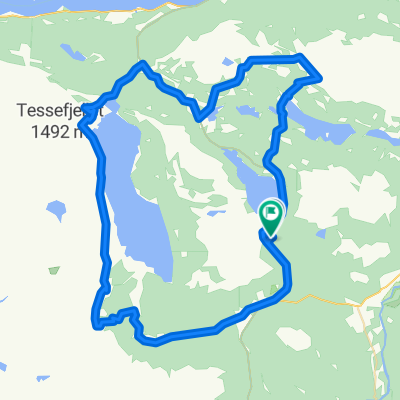
Overview
About this route
- -:--
- Duration
- 234.2 km
- Distance
- 1,811 m
- Ascent
- 2,188 m
- Descent
- ---
- Avg. speed
- ---
- Max. altitude

Route highlights
Points of interest along the route
Point of interest after 0.1 km
Randsverk Camping
Point of interest after 28.1 km
Fiskelyst shelter
Point of interest after 58.5 km
Oskampen hytte selvbetjent
Point of interest after 71.4 km
Haugseter Fjellstue betjent
Point of interest after 99.5 km
Torfinnsby hytte selvbetjent
Point of interest after 119.8 km
Fondsbu fjellstue betjent
Point of interest after 169.5 km
Sørre Hemsing hytte betjent
Continue with Bikemap
Use, edit, or download this cycling route
You would like to ride Mjølkevegen or customize it for your own trip? Here is what you can do with this Bikemap route:
Free features
- Save this route as favorite or in collections
- Copy & plan your own version of this route
- Split it into stages to create a multi-day tour
- Sync your route with Garmin or Wahoo
Premium features
Free trial for 3 days, or one-time payment. More about Bikemap Premium.
- Navigate this route on iOS & Android
- Export a GPX / KML file of this route
- Create your custom printout (try it for free)
- Download this route for offline navigation
Discover more Premium features.
Get Bikemap PremiumFrom our community
Other popular routes starting in Vågåmo
 Mjølkevegen
- Distance
- 234.2 km
- Ascent
- 1,811 m
- Descent
- 2,188 m
- Location
- Vågåmo, Oppland, Norway
 norge O bm partim VALDRESFLYA H+T
- Distance
- 64.9 km
- Ascent
- 397 m
- Descent
- 397 m
- Location
- Vågåmo, Oppland, Norway
 Lemonsjøen - Espedalen - Lillehammer
- Distance
- 194.5 km
- Ascent
- 1,302 m
- Descent
- 1,999 m
- Location
- Vågåmo, Oppland, Norway
 Lemonsjoen Dovre
- Distance
- 51.3 km
- Ascent
- 831 m
- Descent
- 861 m
- Location
- Vågåmo, Oppland, Norway
 NOR 006: Vagamo 1
- Distance
- 98 km
- Ascent
- 0 m
- Descent
- 0 m
- Location
- Vågåmo, Oppland, Norway
 Randsverk-Tesse-Randsverk - roundtrip
- Distance
- 39.6 km
- Ascent
- 581 m
- Descent
- 592 m
- Location
- Vågåmo, Oppland, Norway
 Randsverk-Murudal-Heidal-Randsverk
- Distance
- 39.9 km
- Ascent
- 831 m
- Descent
- 828 m
- Location
- Vågåmo, Oppland, Norway
 NOR 007: Vagamo 2
- Distance
- 61.5 km
- Ascent
- 0 m
- Descent
- 0 m
- Location
- Vågåmo, Oppland, Norway
Open it in the app