

Claudia Augusta route (Fussen AT to Salorno IT)
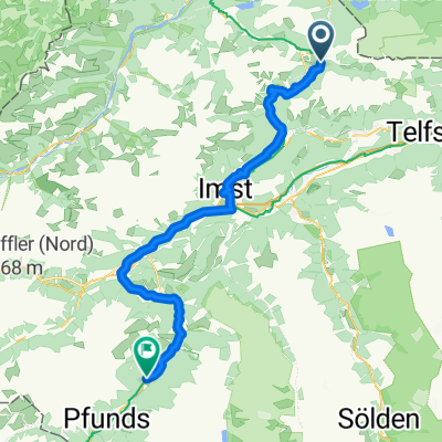
CA2 Biberwier to before Nassereith - by shuttle (Austria)
A cycling route starting in Biberwier, Tyrol, Austria.
Overview
About this route
Done by shuttle on road, not by bike on trails. The area is steep, and would take a longer time by touring bike and with luggage it is not usually done. The shuttle takes around 20 minutes.
This one drops you off before Nassereith. You then have to go back a bit (north) or down to the west by bike to get to the bike trail.
- -:--
- Duration
- 12.6 km
- Distance
- 313 m
- Ascent
- 352 m
- Descent
- ---
- Avg. speed
- 1,226 m
- Max. altitude

Part of
Route quality
Waytypes & surfaces along the route
Waytypes
Busy road
11.6 km
(92 %)
Path
0.5 km
(4 %)
Surfaces
Paved
12.5 km
(100 %)
Unpaved
0 km
(<1 %)
Asphalt
12.2 km
(97 %)
Paving stones
0.3 km
(2 %)
Continue with Bikemap
Use, edit, or download this cycling route
You would like to ride CA2 Biberwier to before Nassereith - by shuttle (Austria) or customize it for your own trip? Here is what you can do with this Bikemap route:
Free features
- Save this route as favorite or in collections
- Copy & plan your own version of this route
- Sync your route with Garmin or Wahoo
Premium features
Free trial for 3 days, or one-time payment. More about Bikemap Premium.
- Navigate this route on iOS & Android
- Export a GPX / KML file of this route
- Create your custom printout (try it for free)
- Download this route for offline navigation
Discover more Premium features.
Get Bikemap PremiumFrom our community
Other popular routes starting in Biberwier
 Gipfeltour Sonnenspitze
- Distance
- 4 km
- Ascent
- 606 m
- Descent
- 614 m
- Location
- Biberwier, Tyrol, Austria
 Ö5Biberw-Garmisch-Ahornbogen (Eng)
- Distance
- 89.6 km
- Ascent
- 1,082 m
- Descent
- 875 m
- Location
- Biberwier, Tyrol, Austria
 Biberwier - Serfaus
- Distance
- 76.6 km
- Ascent
- 1,703 m
- Descent
- 1,739 m
- Location
- Biberwier, Tyrol, Austria
 E2: Biberwier - Zernez
- Distance
- 138.7 km
- Ascent
- 2,893 m
- Descent
- 2,461 m
- Location
- Biberwier, Tyrol, Austria
 MTB Fernpass - Megatrails
- Distance
- 82 km
- Ascent
- 3,542 m
- Descent
- 3,543 m
- Location
- Biberwier, Tyrol, Austria
 L71 64, Biberwier nach Malserstraße 31, Landeck
- Distance
- 54.4 km
- Ascent
- 651 m
- Descent
- 852 m
- Location
- Biberwier, Tyrol, Austria
 z-B31EHR-Biberwier-3 Seen Runde
- Distance
- 11.2 km
- Ascent
- 357 m
- Descent
- 357 m
- Location
- Biberwier, Tyrol, Austria
 8. Etappe: Biberwier - Zams
- Distance
- 59.3 km
- Ascent
- 1,220 m
- Descent
- 1,452 m
- Location
- Biberwier, Tyrol, Austria
Open it in the app