

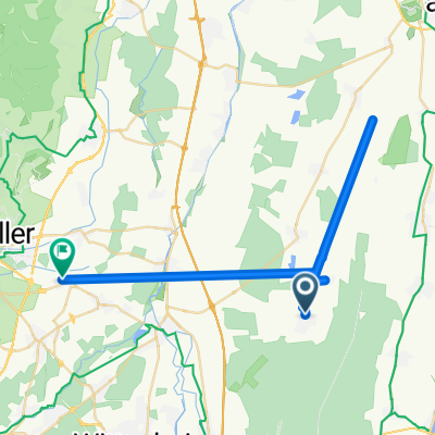
parcours munchhouse
A cycling route starting in Munchhouse, Grand Est, France.
Overview
About this route
- -:--
- Duration
- 24.3 km
- Distance
- 13 m
- Ascent
- 16 m
- Descent
- ---
- Avg. speed
- ---
- Max. altitude

Continue with Bikemap
Use, edit, or download this cycling route
You would like to ride parcours munchhouse or customize it for your own trip? Here is what you can do with this Bikemap route:
Free features
- Save this route as favorite or in collections
- Copy & plan your own version of this route
- Sync your route with Garmin or Wahoo
Premium features
Free trial for 3 days, or one-time payment. More about Bikemap Premium.
- Navigate this route on iOS & Android
- Export a GPX / KML file of this route
- Create your custom printout (try it for free)
- Download this route for offline navigation
Discover more Premium features.
Get Bikemap PremiumFrom our community
Other popular routes starting in Munchhouse
 32 Rue d'Ensisheim, Munchhouse à 32 Rue d'Ensisheim, Munchhouse
- Distance
- 24.9 km
- Ascent
- 42 m
- Descent
- 35 m
- Location
- Munchhouse, Grand Est, France
 sortie en forêt
- Distance
- 29.1 km
- Ascent
- 80 m
- Descent
- 77 m
- Location
- Munchhouse, Grand Est, France
 parcours munchhouse
- Distance
- 24.3 km
- Ascent
- 13 m
- Descent
- 16 m
- Location
- Munchhouse, Grand Est, France
 versuch1
- Distance
- 12.5 km
- Ascent
- 12 m
- Descent
- 7 m
- Location
- Munchhouse, Grand Est, France
 De 6A Rue des Fleurs, Munchhouse à 7 Rue des Fleurs, Munchhouse
- Distance
- 0.3 km
- Ascent
- 3 m
- Descent
- 3 m
- Location
- Munchhouse, Grand Est, France
 De Rue Bains sur Oust à Rue de la Rivière
- Distance
- 36.3 km
- Ascent
- 162 m
- Descent
- 204 m
- Location
- Munchhouse, Grand Est, France
 Sortie mixte !!
- Distance
- 26.3 km
- Ascent
- 53 m
- Descent
- 52 m
- Location
- Munchhouse, Grand Est, France
 on s'améliore
- Distance
- 24.5 km
- Ascent
- 48 m
- Descent
- 37 m
- Location
- Munchhouse, Grand Est, France
Open it in the app