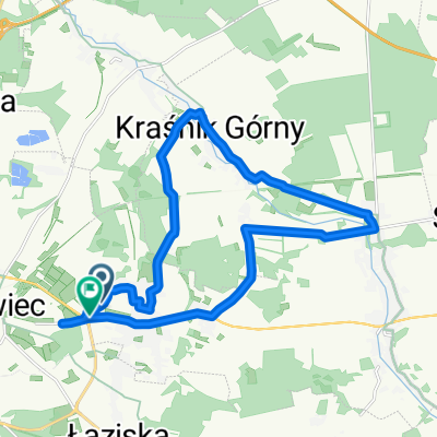
I Rowerowy Rajd na Orientację Warta Bolesławiecka 2019
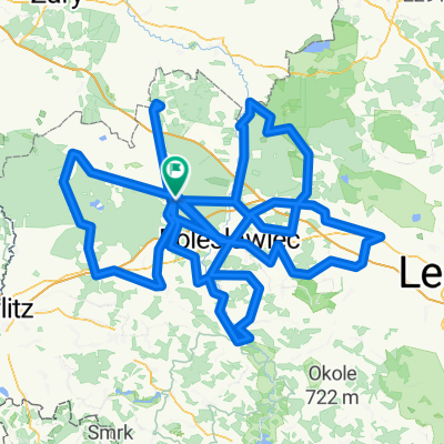
A cycling route starting in Bolesławiec, Lower Silesian Voivodeship, Poland.
Overview
About this route
I Rowerowy Rajd na Orientację Warta Bolesławiecka 2019
- -:--
- Duration
- 29.7 km
- Distance
- 104 m
- Ascent
- 103 m
- Descent
- ---
- Avg. speed
- ---
- Avg. speed
Route quality
Waytypes & surfaces along the route
Waytypes
Road
10.7 km
(36 %)
Quiet road
8.5 km
(29 %)
Surfaces
Paved
9.7 km
(32 %)
Asphalt
9.7 km
(32 %)
Undefined
20.1 km
(68 %)
Continue with Bikemap
Use, edit, or download this cycling route
You would like to ride I Rowerowy Rajd na Orientację Warta Bolesławiecka 2019 or customize it for your own trip? Here is what you can do with this Bikemap route:
Free features
- Save this route as favorite or in collections
- Copy & plan your own version of this route
- Sync your route with Garmin or Wahoo
Premium features
Free trial for 3 days, or one-time payment. More about Bikemap Premium.
- Navigate this route on iOS & Android
- Export a GPX / KML file of this route
- Create your custom printout (try it for free)
- Download this route for offline navigation
Discover more Premium features.
Get Bikemap PremiumFrom our community
Other popular routes starting in Bolesławiec
- Boleslawiec Kliczkow petla polnocna niebieski
- Distance
- 31.3 km
- Ascent
- 125 m
- Descent
- 121 m
- Location
- Bolesławiec, Lower Silesian Voivodeship, Poland
- Bolesławiec - Suszki petla poludniowa
- Distance
- 31.6 km
- Ascent
- 214 m
- Descent
- 221 m
- Location
- Bolesławiec, Lower Silesian Voivodeship, Poland
- Okolice Bolesławca
- Distance
- 389.9 km
- Ascent
- 1,808 m
- Descent
- 1,808 m
- Location
- Bolesławiec, Lower Silesian Voivodeship, Poland
- Kruszyn - Zgorzelec
- Distance
- 70.8 km
- Ascent
- 343 m
- Descent
- 333 m
- Location
- Bolesławiec, Lower Silesian Voivodeship, Poland
- Antywyprawka 5 2018
- Distance
- 164.2 km
- Ascent
- 726 m
- Descent
- 727 m
- Location
- Bolesławiec, Lower Silesian Voivodeship, Poland
- Bolesławiec - Legnica
- Distance
- 61.2 km
- Ascent
- 116 m
- Descent
- 188 m
- Location
- Bolesławiec, Lower Silesian Voivodeship, Poland
- Kruszyn Kraśnik
- Distance
- 19.4 km
- Ascent
- 95 m
- Descent
- 85 m
- Location
- Bolesławiec, Lower Silesian Voivodeship, Poland
- Szlak im. Leona Piątkowskiego pętla północna
- Distance
- 28.3 km
- Ascent
- 160 m
- Descent
- 171 m
- Location
- Bolesławiec, Lower Silesian Voivodeship, Poland
Open it in the app