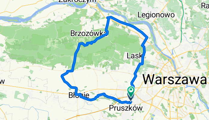
Piastów - Błonie - Leszno - Czosnów - Łomianki - Piastów
A cycling route starting in Piastów, Masovian Voivodeship, Poland.
Overview
About this route
- -:--
- Duration
- 84 km
- Distance
- 53 m
- Ascent
- 49 m
- Descent
- ---
- Avg. speed
- ---
- Avg. speed
Route quality
Waytypes & surfaces along the route
Waytypes
Road
36 km
(43 %)
Busy road
23.3 km
(28 %)
Surfaces
Paved
67 km
(80 %)
Unpaved
0.1 km
(<1 %)
Asphalt
58.9 km
(70 %)
Paving stones
5.2 km
(6 %)
Continue with Bikemap
Use, edit, or download this cycling route
You would like to ride Piastów - Błonie - Leszno - Czosnów - Łomianki - Piastów or customize it for your own trip? Here is what you can do with this Bikemap route:
Free features
- Save this route as favorite or in collections
- Copy & plan your own version of this route
- Sync your route with Garmin or Wahoo
Premium features
Free trial for 3 days, or one-time payment. More about Bikemap Premium.
- Navigate this route on iOS & Android
- Export a GPX / KML file of this route
- Create your custom printout (try it for free)
- Download this route for offline navigation
Discover more Premium features.
Get Bikemap PremiumFrom our community
Other popular routes starting in Piastów
- Piastow - Radom (wzdloz torow)
- Distance
- 129.1 km
- Ascent
- 190 m
- Descent
- 132 m
- Location
- Piastów, Masovian Voivodeship, Poland
- Pruszków - Nadarzyn - Grodzisk - Pruszków
- Distance
- 51.1 km
- Ascent
- 46 m
- Descent
- 46 m
- Location
- Piastów, Masovian Voivodeship, Poland
- Czwartkowa rzeczywistość
- Distance
- 48.3 km
- Ascent
- 46 m
- Descent
- 46 m
- Location
- Piastów, Masovian Voivodeship, Poland
- Kampinos-Secymin nad Wisłą
- Distance
- 101.5 km
- Ascent
- 102 m
- Descent
- 99 m
- Location
- Piastów, Masovian Voivodeship, Poland
- Plażówka
- Distance
- 37 km
- Ascent
- 27 m
- Descent
- 27 m
- Location
- Piastów, Masovian Voivodeship, Poland
- H Brodatego, Warszawa do Koński Jar, Warszawa
- Distance
- 16.7 km
- Ascent
- 29 m
- Descent
- 44 m
- Location
- Piastów, Masovian Voivodeship, Poland
- Kampinos
- Distance
- 54.7 km
- Ascent
- 61 m
- Descent
- 63 m
- Location
- Piastów, Masovian Voivodeship, Poland
- Piastów-Łazy-Gołków-Skuły-Janówek-nadarzyn-piastów
- Distance
- 108.6 km
- Ascent
- 151 m
- Descent
- 153 m
- Location
- Piastów, Masovian Voivodeship, Poland
Open it in the app