

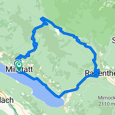
Dráva túra 2. nap
A cycling route starting in Millstatt, Carinthia, Austria.
Overview
About this route
- 9 h 30 min
- Duration
- 133 km
- Distance
- 523 m
- Ascent
- 729 m
- Descent
- 14 km/h
- Avg. speed
- ---
- Max. altitude

Route photos


Route quality
Waytypes & surfaces along the route
Waytypes
Cycleway
54.5 km
(41 %)
Track
41.2 km
(31 %)
Surfaces
Paved
37.2 km
(28 %)
Unpaved
70.5 km
(53 %)
Gravel
43.9 km
(33 %)
Asphalt
34.6 km
(26 %)
Continue with Bikemap
Use, edit, or download this cycling route
You would like to ride Dráva túra 2. nap or customize it for your own trip? Here is what you can do with this Bikemap route:
Free features
- Save this route as favorite or in collections
- Copy & plan your own version of this route
- Split it into stages to create a multi-day tour
- Sync your route with Garmin or Wahoo
Premium features
Free trial for 3 days, or one-time payment. More about Bikemap Premium.
- Navigate this route on iOS & Android
- Export a GPX / KML file of this route
- Create your custom printout (try it for free)
- Download this route for offline navigation
Discover more Premium features.
Get Bikemap PremiumFrom our community
Other popular routes starting in Millstatt
 49 ebike
- Distance
- 43.7 km
- Ascent
- 1,475 m
- Descent
- 1,475 m
- Location
- Millstatt, Carinthia, Austria
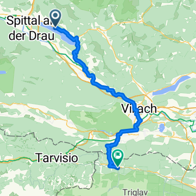 Spittal an der Drau - Tarvisio
- Distance
- 67.8 km
- Ascent
- 1,567 m
- Descent
- 1,353 m
- Location
- Millstatt, Carinthia, Austria
 Dráva túra 2. nap
- Distance
- 133 km
- Ascent
- 523 m
- Descent
- 729 m
- Location
- Millstatt, Carinthia, Austria
 Millstatt round
- Distance
- 30.7 km
- Ascent
- 424 m
- Descent
- 435 m
- Location
- Millstatt, Carinthia, Austria
 Molzbichl nach Molzbichl
- Distance
- 55.5 km
- Ascent
- 652 m
- Descent
- 703 m
- Location
- Millstatt, Carinthia, Austria
 Molzbichl nach Molzbichl
- Distance
- 27.3 km
- Ascent
- 322 m
- Descent
- 371 m
- Location
- Millstatt, Carinthia, Austria
 Molzbichl nach Molzbichl
- Distance
- 45.3 km
- Ascent
- 1,378 m
- Descent
- 1,429 m
- Location
- Millstatt, Carinthia, Austria
 Lechnerschaft 661/1 nach Lechnerschaft 661/1
- Distance
- 29.3 km
- Ascent
- 408 m
- Descent
- 406 m
- Location
- Millstatt, Carinthia, Austria
Open it in the app