
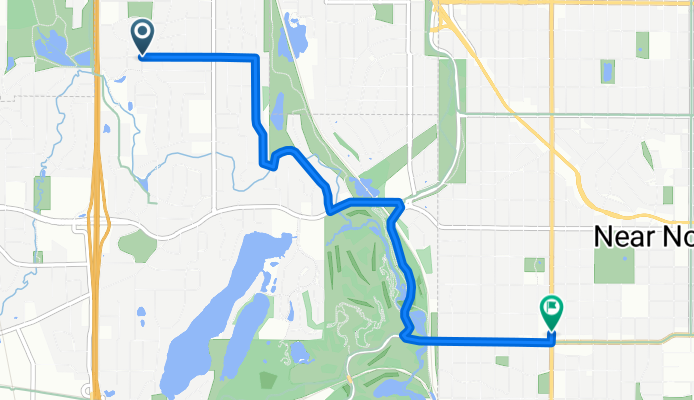
B2B00321 55442>55411 via Culver Rd, Kyle Ave, Theo Wirth Pkwy & Plymouth Ave
A cycling route starting in Golden Valley, Minnesota, United States.
Overview
About this route
The shoulder on Golden Valley Rd is unreliable which is why the route attempts to avoid it, except for a short stretch. There is a path along the road.
Theo Wirth Pkwy has bike paths.
- -:--
- Duration
- 5 km
- Distance
- 37 m
- Ascent
- 37 m
- Descent
- ---
- Avg. speed
- 273 m
- Max. altitude
Route quality
Waytypes & surfaces along the route
Waytypes
Quiet road
2.4 km
(47 %)
Road
1.8 km
(35 %)
Surfaces
Paved
4.9 km
(98 %)
Asphalt
2.8 km
(56 %)
Paved (undefined)
1.3 km
(25 %)
Continue with Bikemap
Use, edit, or download this cycling route
You would like to ride B2B00321 55442>55411 via Culver Rd, Kyle Ave, Theo Wirth Pkwy & Plymouth Ave or customize it for your own trip? Here is what you can do with this Bikemap route:
Free features
- Save this route as favorite or in collections
- Copy & plan your own version of this route
- Sync your route with Garmin or Wahoo
Premium features
Free trial for 3 days, or one-time payment. More about Bikemap Premium.
- Navigate this route on iOS & Android
- Export a GPX / KML file of this route
- Create your custom printout (try it for free)
- Download this route for offline navigation
Discover more Premium features.
Get Bikemap PremiumFrom our community
Other popular routes starting in Golden Valley
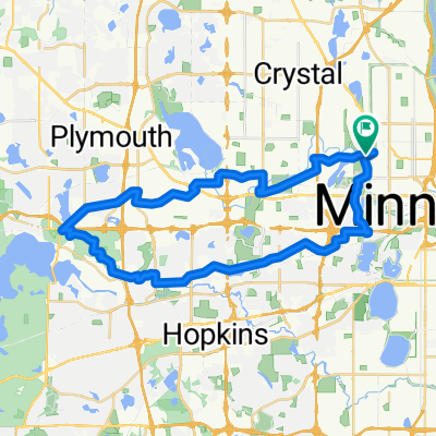 Wirth-Mtka-North 41k
- Distance
- 41.1 km
- Ascent
- 192 m
- Descent
- 201 m
- Location
- Golden Valley, Minnesota, United States
 B2B00321 55442>55411 via Culver Rd, Kyle Ave, Theo Wirth Pkwy & Plymouth Ave
- Distance
- 5 km
- Ascent
- 37 m
- Descent
- 37 m
- Location
- Golden Valley, Minnesota, United States
 6/28/19
- Distance
- 17.9 km
- Ascent
- 74 m
- Descent
- 77 m
- Location
- Golden Valley, Minnesota, United States
 44 Mile Tour D'Amico
- Distance
- 66.9 km
- Ascent
- 201 m
- Descent
- 201 m
- Location
- Golden Valley, Minnesota, United States
 B2B00088 55411 > 55111 via downtown, Light Rail trail, and Minnehaha park
- Distance
- 18.8 km
- Ascent
- 39 m
- Descent
- 95 m
- Location
- Golden Valley, Minnesota, United States
 Luce around Minnetonka
- Distance
- 80 km
- Ascent
- 145 m
- Descent
- 138 m
- Location
- Golden Valley, Minnesota, United States
 edina route66
- Distance
- 46.2 km
- Ascent
- 116 m
- Descent
- 117 m
- Location
- Golden Valley, Minnesota, United States
 Loop 5/20/20
- Distance
- 14.8 km
- Ascent
- 95 m
- Descent
- 93 m
- Location
- Golden Valley, Minnesota, United States
Open it in the app