
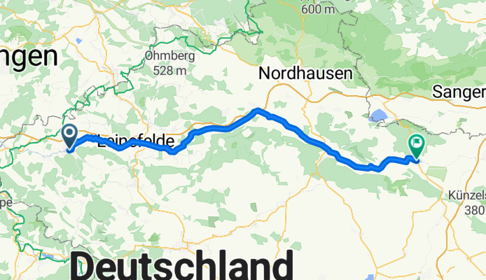
Heilbad Heiligenstadt - Bad Frankenhausen
A cycling route starting in Heilbad Heiligenstadt, Free State of Thuringia, Germany.
Overview
About this route
Warburg - Weimar (3. Etappe)
Erstaunlich leichte Fahrt, vor allem im 2. Teil mit sanften Gefällestrecken und Rückenwind.
- -:--
- Duration
- 81.7 km
- Distance
- 192 m
- Ascent
- 323 m
- Descent
- ---
- Avg. speed
- ---
- Max. altitude

Route quality
Waytypes & surfaces along the route
Waytypes
Quiet road
22.9 km
(28 %)
Busy road
16.5 km
(20 %)
Surfaces
Paved
63.4 km
(78 %)
Unpaved
1.4 km
(2 %)
Asphalt
58.4 km
(71 %)
Paving stones
3.7 km
(5 %)
Continue with Bikemap
Use, edit, or download this cycling route
You would like to ride Heilbad Heiligenstadt - Bad Frankenhausen or customize it for your own trip? Here is what you can do with this Bikemap route:
Free features
- Save this route as favorite or in collections
- Copy & plan your own version of this route
- Split it into stages to create a multi-day tour
- Sync your route with Garmin or Wahoo
Premium features
Free trial for 3 days, or one-time payment. More about Bikemap Premium.
- Navigate this route on iOS & Android
- Export a GPX / KML file of this route
- Create your custom printout (try it for free)
- Download this route for offline navigation
Discover more Premium features.
Get Bikemap PremiumFrom our community
Other popular routes starting in Heilbad Heiligenstadt
 mini runde vorm regen
- Distance
- 16.8 km
- Ascent
- 375 m
- Descent
- 374 m
- Location
- Heilbad Heiligenstadt, Free State of Thuringia, Germany
 HIG- Steinheuterr.-Schachtebich-Rohrbg.-Vogelsang- Bischh.-Siemerode- Mengelrode-HIG
- Distance
- 31.4 km
- Ascent
- 289 m
- Descent
- 289 m
- Location
- Heilbad Heiligenstadt, Free State of Thuringia, Germany
 Heiligenstadt-Leinefelde_Köhlersgrund-A 38-Wingerode-Leineradweg-Heiligenwstadt
- Distance
- 30.4 km
- Ascent
- 172 m
- Descent
- 172 m
- Location
- Heilbad Heiligenstadt, Free State of Thuringia, Germany
 Pedalritter-2010-T4-Heiligenstadt-SZ
- Distance
- 130.6 km
- Ascent
- 664 m
- Descent
- 804 m
- Location
- Heilbad Heiligenstadt, Free State of Thuringia, Germany
 HIG (Stormhügel)-Beberberg-Rießbach-Günterode-HIG
- Distance
- 19.7 km
- Ascent
- 251 m
- Descent
- 251 m
- Location
- Heilbad Heiligenstadt, Free State of Thuringia, Germany
 Arensh.- Oberst.- Eckstieg- Marth- Opferstein- Burgwalde- u.z.
- Distance
- 33.5 km
- Ascent
- 243 m
- Descent
- 243 m
- Location
- Heilbad Heiligenstadt, Free State of Thuringia, Germany
 HIG Dieterode HIG vom 19. Juni 14:50
- Distance
- 31.3 km
- Ascent
- 331 m
- Descent
- 351 m
- Location
- Heilbad Heiligenstadt, Free State of Thuringia, Germany
 Eichsfeldrundfahrt
- Distance
- 99.7 km
- Ascent
- 919 m
- Descent
- 925 m
- Location
- Heilbad Heiligenstadt, Free State of Thuringia, Germany
Open it in the app