

Brønnøya
A cycling route starting in Sjølyststranda, Oslo County, Norway.
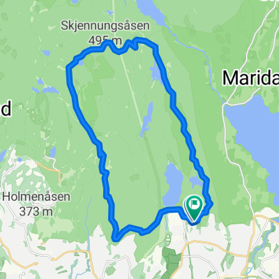
Overview
About this route
- -:--
- Duration
- 18.3 km
- Distance
- 95 m
- Ascent
- 178 m
- Descent
- ---
- Avg. speed
- ---
- Max. altitude

Route quality
Waytypes & surfaces along the route
Waytypes
Cycleway
7.9 km
(43 %)
Quiet road
3.5 km
(19 %)
Surfaces
Paved
16.1 km
(88 %)
Asphalt
16.1 km
(88 %)
Undefined
2.2 km
(12 %)
Route highlights
Points of interest along the route
Point of interest after 6.3 km
xx
Continue with Bikemap
Use, edit, or download this cycling route
You would like to ride Brønnøya or customize it for your own trip? Here is what you can do with this Bikemap route:
Free features
- Save this route as favorite or in collections
- Copy & plan your own version of this route
- Sync your route with Garmin or Wahoo
Premium features
Free trial for 3 days, or one-time payment. More about Bikemap Premium.
- Navigate this route on iOS & Android
- Export a GPX / KML file of this route
- Create your custom printout (try it for free)
- Download this route for offline navigation
Discover more Premium features.
Get Bikemap PremiumFrom our community
Other popular routes starting in Sjølyststranda
 Brønnøya
- Distance
- 18.3 km
- Ascent
- 95 m
- Descent
- 178 m
- Location
- Sjølyststranda, Oslo County, Norway
 Oslo/Maridalen/Hakloa/Trehjørningen/Greveveien
- Distance
- 66.1 km
- Ascent
- 600 m
- Descent
- 600 m
- Location
- Sjølyststranda, Oslo County, Norway
 sørkedalen
- Distance
- 23 km
- Ascent
- 327 m
- Descent
- 327 m
- Location
- Sjølyststranda, Oslo County, Norway
 Dag0-Oslo
- Distance
- 10.9 km
- Ascent
- 105 m
- Descent
- 219 m
- Location
- Sjølyststranda, Oslo County, Norway
 Route van Frognerseteren
- Distance
- 14.3 km
- Ascent
- 151 m
- Descent
- 654 m
- Location
- Sjølyststranda, Oslo County, Norway
 sognsvann-bånntjern-vettakollen-skjennung-ullevålseter-svartkulp
- Distance
- 16.7 km
- Ascent
- 368 m
- Descent
- 370 m
- Location
- Sjølyststranda, Oslo County, Norway
 Skjennungstua/Ullevålseter runde
- Distance
- 17.5 km
- Ascent
- 364 m
- Descent
- 365 m
- Location
- Sjølyststranda, Oslo County, Norway
 Tryvann/Sandungen
- Distance
- 55.9 km
- Ascent
- 784 m
- Descent
- 784 m
- Location
- Sjølyststranda, Oslo County, Norway
Open it in the app