

Voyage 2019 de Chalon sur Saône à Chalon sur Saône
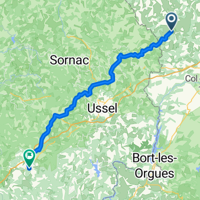
Etape 04 - Condat en Chambraille à Bugeat - 72,3km 800D+
A cycling route starting in Gelles, Auvergne-Rhône-Alpes, France.
Overview
About this route
Stage - Camping at the gates of the thousand springs
Phone 05 55 94 32 12
- -:--
- Duration
- 72.3 km
- Distance
- 624 m
- Ascent
- 631 m
- Descent
- ---
- Avg. speed
- ---
- Max. altitude

Part of
Route quality
Waytypes & surfaces along the route
Waytypes
Road
23.1 km
(32 %)
Quiet road
5.8 km
(8 %)
Surfaces
Paved
18.1 km
(25 %)
Unpaved
0.7 km
(1 %)
Asphalt
18.1 km
(25 %)
Ground
0.7 km
(1 %)
Undefined
53.5 km
(74 %)
Continue with Bikemap
Use, edit, or download this cycling route
You would like to ride Etape 04 - Condat en Chambraille à Bugeat - 72,3km 800D+ or customize it for your own trip? Here is what you can do with this Bikemap route:
Free features
- Save this route as favorite or in collections
- Copy & plan your own version of this route
- Sync your route with Garmin or Wahoo
Premium features
Free trial for 3 days, or one-time payment. More about Bikemap Premium.
- Navigate this route on iOS & Android
- Export a GPX / KML file of this route
- Create your custom printout (try it for free)
- Download this route for offline navigation
Discover more Premium features.
Get Bikemap PremiumFrom our community
Other popular routes starting in Gelles
 sancy
sancy- Distance
- 119 km
- Ascent
- 2,724 m
- Descent
- 2,753 m
- Location
- Gelles, Auvergne-Rhône-Alpes, France
 Tortebesse vtt 2 35km
- Distance
- 35.2 km
- Ascent
- 723 m
- Descent
- 724 m
- Location
- Gelles, Auvergne-Rhône-Alpes, France
 Gelles - Égletons
- Distance
- 76.5 km
- Ascent
- 1,329 m
- Descent
- 1,443 m
- Location
- Gelles, Auvergne-Rhône-Alpes, France
 Etape 04 - Condat en Chambraille à Bugeat - 76,5km 830D+
- Distance
- 76.5 km
- Ascent
- 754 m
- Descent
- 760 m
- Location
- Gelles, Auvergne-Rhône-Alpes, France
 Puy de Dome 8.6.2009
- Distance
- 50.8 km
- Ascent
- 1,107 m
- Descent
- 1,107 m
- Location
- Gelles, Auvergne-Rhône-Alpes, France
 Etape 04 - Condat en Chambraille à Bugeat - 72,3km 800D+
- Distance
- 72.3 km
- Ascent
- 624 m
- Descent
- 631 m
- Location
- Gelles, Auvergne-Rhône-Alpes, France
 z Rochefort - Montagne na Puy de Dome
- Distance
- 28.9 km
- Ascent
- 1,064 m
- Descent
- 489 m
- Location
- Gelles, Auvergne-Rhône-Alpes, France
 Randonné des sources minérales du Massif Central partie 4
- Distance
- 90.3 km
- Ascent
- 1,647 m
- Descent
- 2,110 m
- Location
- Gelles, Auvergne-Rhône-Alpes, France
Open it in the app