

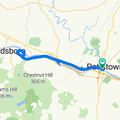
River Trail
A cycling route starting in Pottstown, Pennsylvania, United States.
Overview
About this route
- -:--
- Duration
- 11.5 km
- Distance
- 34 m
- Ascent
- 35 m
- Descent
- ---
- Avg. speed
- ---
- Max. altitude

Route quality
Waytypes & surfaces along the route
Waytypes
Cycleway
11.4 km
(99 %)
Access road
0.1 km
(1 %)
Surfaces
Paved
10.6 km
(92 %)
Unpaved
0.8 km
(7 %)
Paved (undefined)
10.6 km
(92 %)
Loose gravel
0.8 km
(7 %)
Undefined
0.1 km
(1 %)
Continue with Bikemap
Use, edit, or download this cycling route
You would like to ride River Trail or customize it for your own trip? Here is what you can do with this Bikemap route:
Free features
- Save this route as favorite or in collections
- Copy & plan your own version of this route
- Sync your route with Garmin or Wahoo
Premium features
Free trial for 3 days, or one-time payment. More about Bikemap Premium.
- Navigate this route on iOS & Android
- Export a GPX / KML file of this route
- Create your custom printout (try it for free)
- Download this route for offline navigation
Discover more Premium features.
Get Bikemap PremiumFrom our community
Other popular routes starting in Pottstown
 College Drive 140, Pottstown to College Drive 140, Pottstown
- Distance
- 27.2 km
- Ascent
- 71 m
- Descent
- 44 m
- Location
- Pottstown, Pennsylvania, United States
 381 Beech St, Pottstown to 439 Beech St, Pottstown
- Distance
- 0.2 km
- Ascent
- 6 m
- Descent
- 0 m
- Location
- Pottstown, Pennsylvania, United States
 Beech Street 7, Pottstown to Upper Fricks Lock Road 163, Pottstown
- Distance
- 6.3 km
- Ascent
- 57 m
- Descent
- 33 m
- Location
- Pottstown, Pennsylvania, United States
 College Dr, Pottstown to College Dr, Pottstown
- Distance
- 16.2 km
- Ascent
- 652 m
- Descent
- 655 m
- Location
- Pottstown, Pennsylvania, United States
 143–171 S Washington St, Pottstown to 100 E Ward Ave, Ridley Park
- Distance
- 62.6 km
- Ascent
- 456 m
- Descent
- 470 m
- Location
- Pottstown, Pennsylvania, United States
 Beech Street 7, Pottstown to Upper Fricks Lock Road 163, Pottstown
- Distance
- 6.3 km
- Ascent
- 57 m
- Descent
- 33 m
- Location
- Pottstown, Pennsylvania, United States
 Extensive Morning Ride In Pottstown
- Distance
- 29.6 km
- Ascent
- 56 m
- Descent
- 60 m
- Location
- Pottstown, Pennsylvania, United States
 College Dr, Pottstown to College Dr, Pottstown
- Distance
- 16.3 km
- Ascent
- 503 m
- Descent
- 504 m
- Location
- Pottstown, Pennsylvania, United States
Open it in the app