

DAY 5
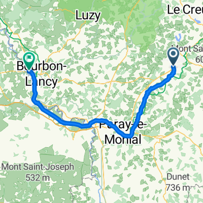
A cycling route starting in Saint-Vallier, Bourgogne-Franche-Comté, France.
Overview
About this route
- -:--
- Duration
- 78.7 km
- Distance
- 40 m
- Ascent
- 103 m
- Descent
- ---
- Avg. speed
- ---
- Max. altitude
Route quality
Waytypes & surfaces along the route
Waytypes
Path
42.5 km
(54 %)
Road
25.2 km
(32 %)
Surfaces
Paved
44.9 km
(57 %)
Unpaved
1.6 km
(2 %)
Asphalt
40.1 km
(51 %)
Paved (undefined)
4.7 km
(6 %)
Continue with Bikemap
Use, edit, or download this cycling route
You would like to ride DAY 5 or customize it for your own trip? Here is what you can do with this Bikemap route:
Free features
- Save this route as favorite or in collections
- Copy & plan your own version of this route
- Sync your route with Garmin or Wahoo
Premium features
Free trial for 3 days, or one-time payment. More about Bikemap Premium.
- Navigate this route on iOS & Android
- Export a GPX / KML file of this route
- Create your custom printout (try it for free)
- Download this route for offline navigation
Discover more Premium features.
Get Bikemap PremiumFrom our community
Other popular routes starting in Saint-Vallier
 Tag 3
Tag 3- Distance
- 47.1 km
- Ascent
- 474 m
- Descent
- 469 m
- Location
- Saint-Vallier, Bourgogne-Franche-Comté, France
 De Rue du Chèvrefeuille 3, Saint-Vallier à Rue du Chèvrefeuille 3, Saint-Vallier
- Distance
- 6.8 km
- Ascent
- 156 m
- Descent
- 156 m
- Location
- Saint-Vallier, Bourgogne-Franche-Comté, France
 La Guiche
- Distance
- 63.1 km
- Ascent
- 629 m
- Descent
- 629 m
- Location
- Saint-Vallier, Bourgogne-Franche-Comté, France
 Palinges
- Distance
- 46.5 km
- Ascent
- 241 m
- Descent
- 249 m
- Location
- Saint-Vallier, Bourgogne-Franche-Comté, France
 20200723 Day 7c - Saint-Vallier à Palinges
- Distance
- 20.8 km
- Ascent
- 126 m
- Descent
- 219 m
- Location
- Saint-Vallier, Bourgogne-Franche-Comté, France
 B04 Saint-Romain sous Gourdon - Pierrerfitte-sur-Loire
- Distance
- 73.8 km
- Ascent
- 511 m
- Descent
- 619 m
- Location
- Saint-Vallier, Bourgogne-Franche-Comté, France
 DAY 5
DAY 5- Distance
- 78.7 km
- Ascent
- 40 m
- Descent
- 103 m
- Location
- Saint-Vallier, Bourgogne-Franche-Comté, France
 König 2020
- Distance
- 64.7 km
- Ascent
- 787 m
- Descent
- 782 m
- Location
- Saint-Vallier, Bourgogne-Franche-Comté, France
Open it in the app