

test
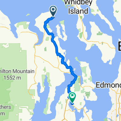
A cycling route starting in Port Townsend, Washington, United States.
Overview
About this route
- -:--
- Duration
- 11.5 km
- Distance
- 168 m
- Ascent
- 125 m
- Descent
- ---
- Avg. speed
- ---
- Max. altitude

Route quality
Waytypes & surfaces along the route
Waytypes
Cycleway
6.7 km
(58 %)
Quiet road
0.8 km
(7 %)
Surfaces
Paved
5 km
(43 %)
Unpaved
6.1 km
(53 %)
Ground
6 km
(52 %)
Asphalt
3.8 km
(33 %)
Continue with Bikemap
Use, edit, or download this cycling route
You would like to ride test or customize it for your own trip? Here is what you can do with this Bikemap route:
Free features
- Save this route as favorite or in collections
- Copy & plan your own version of this route
- Sync your route with Garmin or Wahoo
Premium features
Free trial for 3 days, or one-time payment. More about Bikemap Premium.
- Navigate this route on iOS & Android
- Export a GPX / KML file of this route
- Create your custom printout (try it for free)
- Download this route for offline navigation
Discover more Premium features.
Get Bikemap PremiumFrom our community
Other popular routes starting in Port Townsend
 test
test- Distance
- 11.5 km
- Ascent
- 168 m
- Descent
- 125 m
- Location
- Port Townsend, Washington, United States
 pt to lc
- Distance
- 115.2 km
- Ascent
- 831 m
- Descent
- 643 m
- Location
- Port Townsend, Washington, United States
 Day 1
Day 1- Distance
- 122.1 km
- Ascent
- 669 m
- Descent
- 606 m
- Location
- Port Townsend, Washington, United States
 30 miles to Chimacum, Fort Worden, Downtown and back
- Distance
- 46.6 km
- Ascent
- 327 m
- Descent
- 324 m
- Location
- Port Townsend, Washington, United States
 Port Townsend to Fort Flagler
- Distance
- 62.1 km
- Ascent
- 380 m
- Descent
- 449 m
- Location
- Port Townsend, Washington, United States
 1300–1398 Clay St, Port Townsend to 18680 State Highway 305 NE, Poulsbo
- Distance
- 63.9 km
- Ascent
- 997 m
- Descent
- 1,005 m
- Location
- Port Townsend, Washington, United States
 tyler walk
- Distance
- 3.8 km
- Ascent
- 50 m
- Descent
- 49 m
- Location
- Port Townsend, Washington, United States
 Larry Scott
- Distance
- 30.7 km
- Ascent
- 345 m
- Descent
- 347 m
- Location
- Port Townsend, Washington, United States
Open it in the app