ALTEN >DACHSEN> ALTEN
A cycling route starting in Andelfingen, Canton of Zurich, Switzerland.
Overview
About this route
- -:--
- Duration
- 30.1 km
- Distance
- 277 m
- Ascent
- 278 m
- Descent
- ---
- Avg. speed
- ---
- Avg. speed
Route quality
Waytypes & surfaces along the route
Waytypes
Track
10.5 km
(35 %)
Quiet road
9.5 km
(31 %)
Surfaces
Paved
15 km
(50 %)
Unpaved
13.6 km
(45 %)
Asphalt
15 km
(50 %)
Gravel
7.9 km
(26 %)
Continue with Bikemap
Use, edit, or download this cycling route
You would like to ride ALTEN >DACHSEN> ALTEN or customize it for your own trip? Here is what you can do with this Bikemap route:
Free features
- Save this route as favorite or in collections
- Copy & plan your own version of this route
- Sync your route with Garmin or Wahoo
Premium features
Free trial for 3 days, or one-time payment. More about Bikemap Premium.
- Navigate this route on iOS & Android
- Export a GPX / KML file of this route
- Create your custom printout (try it for free)
- Download this route for offline navigation
Discover more Premium features.
Get Bikemap PremiumFrom our community
Other popular routes starting in Andelfingen
- ALTEN >DACHSEN> ALTEN
- Distance
- 30.1 km
- Ascent
- 277 m
- Descent
- 278 m
- Location
- Andelfingen, Canton of Zurich, Switzerland
- Andelfingen Rhein Route
- Distance
- 37.7 km
- Ascent
- 289 m
- Descent
- 290 m
- Location
- Andelfingen, Canton of Zurich, Switzerland
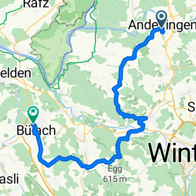
- Irchel Bike Trophy kurz
- Distance
- 34.5 km
- Ascent
- 511 m
- Descent
- 519 m
- Location
- Andelfingen, Canton of Zurich, Switzerland
- Andelfingen Husemersee
- Distance
- 11.7 km
- Ascent
- 171 m
- Descent
- 175 m
- Location
- Andelfingen, Canton of Zurich, Switzerland
- Adlikon-Sternenberg
- Distance
- 59.5 km
- Ascent
- 709 m
- Descent
- 709 m
- Location
- Andelfingen, Canton of Zurich, Switzerland
- See-Route
- Distance
- 15.5 km
- Ascent
- 183 m
- Descent
- 148 m
- Location
- Andelfingen, Canton of Zurich, Switzerland
- Reben-Route
- Distance
- 16 km
- Ascent
- 177 m
- Descent
- 143 m
- Location
- Andelfingen, Canton of Zurich, Switzerland
- Projet Trekking Andelfingen/Bad Zurzach
- Distance
- 37.4 km
- Ascent
- 284 m
- Descent
- 329 m
- Location
- Andelfingen, Canton of Zurich, Switzerland
Open it in the app