

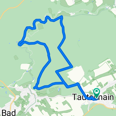
Mühltalrunde MTB
A cycling route starting in Tautenhain, Thuringia, Germany.
Overview
About this route
Not very long but a punchy MTB route with nice climbs (about 350-400m elevation) and fast descents. Ideal for training.
- -:--
- Duration
- 17.6 km
- Distance
- 301 m
- Ascent
- 301 m
- Descent
- ---
- Avg. speed
- ---
- Max. altitude

Route quality
Waytypes & surfaces along the route
Waytypes
Track
9.5 km
(54 %)
Quiet road
6.9 km
(39 %)
Surfaces
Paved
11.5 km
(65 %)
Unpaved
5.8 km
(33 %)
Asphalt
8.8 km
(50 %)
Ground
3 km
(17 %)
Continue with Bikemap
Use, edit, or download this cycling route
You would like to ride Mühltalrunde MTB or customize it for your own trip? Here is what you can do with this Bikemap route:
Free features
- Save this route as favorite or in collections
- Copy & plan your own version of this route
- Sync your route with Garmin or Wahoo
Premium features
Free trial for 3 days, or one-time payment. More about Bikemap Premium.
- Navigate this route on iOS & Android
- Export a GPX / KML file of this route
- Create your custom printout (try it for free)
- Download this route for offline navigation
Discover more Premium features.
Get Bikemap PremiumFrom our community
Other popular routes starting in Tautenhain
 Mühltalrunde MTB
- Distance
- 17.6 km
- Ascent
- 301 m
- Descent
- 301 m
- Location
- Tautenhain, Thuringia, Germany
 Tautenhain- Muehltal und zurück
- Distance
- 15.8 km
- Ascent
- 273 m
- Descent
- 273 m
- Location
- Tautenhain, Thuringia, Germany
 Rund um Bad Köstritz
- Distance
- 29.5 km
- Ascent
- 343 m
- Descent
- 343 m
- Location
- Tautenhain, Thuringia, Germany
 Tautenburg / Dornburger Schlösser
- Distance
- 71.6 km
- Ascent
- 613 m
- Descent
- 613 m
- Location
- Tautenhain, Thuringia, Germany
 Gemütliche Route in Tautenhain
- Distance
- 13.4 km
- Ascent
- 440 m
- Descent
- 442 m
- Location
- Tautenhain, Thuringia, Germany
 Stetige Fahrt
- Distance
- 6.7 km
- Ascent
- 21 m
- Descent
- 99 m
- Location
- Tautenhain, Thuringia, Germany
 Tautenhain, Reichardsdorf, Köstritz,Mühltal, Tautenhain CLONED FROM ROUTE 506560
- Distance
- 27.9 km
- Ascent
- 241 m
- Descent
- 241 m
- Location
- Tautenhain, Thuringia, Germany
 Tautenhain, Reichardsdorf, Köstritz,Mühltal, Tautenhain CLONED FROM ROUTE 506560
- Distance
- 28 km
- Ascent
- 218 m
- Descent
- 218 m
- Location
- Tautenhain, Thuringia, Germany
Open it in the app