
Dordogne
Sarlat -- Beynac - Route 1
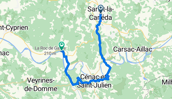
A cycling route starting in Sarlat-la-Canéda, Nouvelle-Aquitaine, France.
Overview
About this route
Straight down to Domme, doesn't follow the river, goes up through Castelnaud-la-Chapelle
- -:--
- Duration
- 25.9 km
- Distance
- 343 m
- Ascent
- 391 m
- Descent
- ---
- Avg. speed
- ---
- Max. altitude

Part of
Dordogne
7 stages
Route quality
Waytypes & surfaces along the route
Waytypes
Quiet road
8.6 km
(33 %)
Road
5.2 km
(20 %)
Surfaces
Paved
22.8 km
(88 %)
Unpaved
0.8 km
(3 %)
Asphalt
22.8 km
(88 %)
Ground
0.8 km
(3 %)
Undefined
2.3 km
(9 %)
Continue with Bikemap
Use, edit, or download this cycling route
You would like to ride Sarlat -- Beynac - Route 1 or customize it for your own trip? Here is what you can do with this Bikemap route:
Free features
- Save this route as favorite or in collections
- Copy & plan your own version of this route
- Sync your route with Garmin or Wahoo
Premium features
Free trial for 3 days, or one-time payment. More about Bikemap Premium.
- Navigate this route on iOS & Android
- Export a GPX / KML file of this route
- Create your custom printout (try it for free)
- Download this route for offline navigation
Discover more Premium features.
Get Bikemap PremiumFrom our community
Other popular routes starting in Sarlat-la-Canéda
 sarlat naar Vitrac
- Distance
- 8.4 km
- Ascent
- 130 m
- Descent
- 203 m
- Location
- Sarlat-la-Canéda, Nouvelle-Aquitaine, France
 Sarlat de Caneda erste Planung
- Distance
- 9.3 km
- Ascent
- 193 m
- Descent
- 196 m
- Location
- Sarlat-la-Canéda, Nouvelle-Aquitaine, France
 Sarlat la Caneda
- Distance
- 64.2 km
- Ascent
- 791 m
- Descent
- 793 m
- Location
- Sarlat-la-Canéda, Nouvelle-Aquitaine, France
 Sarlat Canéda : La voie verte
- Distance
- 41.4 km
- Ascent
- 431 m
- Descent
- 430 m
- Location
- Sarlat-la-Canéda, Nouvelle-Aquitaine, France
 Sarlat - Cabanes-du-Breuil - Marquay a zpět do Sarlatu
- Distance
- 32.8 km
- Ascent
- 488 m
- Descent
- 491 m
- Location
- Sarlat-la-Canéda, Nouvelle-Aquitaine, France
 Circuit de Proissans
- Distance
- 4.5 km
- Ascent
- 103 m
- Descent
- 103 m
- Location
- Sarlat-la-Canéda, Nouvelle-Aquitaine, France
 Liberty Cycle - Sortie Vélo de Route
- Distance
- 32.7 km
- Ascent
- 596 m
- Descent
- 596 m
- Location
- Sarlat-la-Canéda, Nouvelle-Aquitaine, France
 Stage UCSARLAT
- Distance
- 84.6 km
- Ascent
- 406 m
- Descent
- 406 m
- Location
- Sarlat-la-Canéda, Nouvelle-Aquitaine, France
Open it in the app