
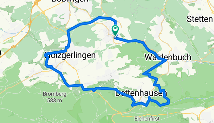
Schönaich - Waldenbuch - Schönbuch -Holzgerlingen - Schönaich
A cycling route starting in Schönaich, Baden-Wurttemberg, Germany.
Overview
About this route
- -:--
- Duration
- 40.4 km
- Distance
- 406 m
- Ascent
- 410 m
- Descent
- ---
- Avg. speed
- ---
- Max. altitude
Route quality
Waytypes & surfaces along the route
Waytypes
Track
28.7 km
(71 %)
Quiet road
4.4 km
(11 %)
Surfaces
Paved
17.4 km
(43 %)
Unpaved
21.4 km
(53 %)
Asphalt
17 km
(42 %)
Gravel
10.1 km
(25 %)
Continue with Bikemap
Use, edit, or download this cycling route
You would like to ride Schönaich - Waldenbuch - Schönbuch -Holzgerlingen - Schönaich or customize it for your own trip? Here is what you can do with this Bikemap route:
Free features
- Save this route as favorite or in collections
- Copy & plan your own version of this route
- Sync your route with Garmin or Wahoo
Premium features
Free trial for 3 days, or one-time payment. More about Bikemap Premium.
- Navigate this route on iOS & Android
- Export a GPX / KML file of this route
- Create your custom printout (try it for free)
- Download this route for offline navigation
Discover more Premium features.
Get Bikemap PremiumFrom our community
Other popular routes starting in Schönaich
 Schönaicher Runde
- Distance
- 8.6 km
- Ascent
- 125 m
- Descent
- 125 m
- Location
- Schönaich, Baden-Wurttemberg, Germany
 Recording from 07 Apr 2016 18:38
- Distance
- 10.9 km
- Ascent
- 159 m
- Descent
- 111 m
- Location
- Schönaich, Baden-Wurttemberg, Germany
 Schönaich->Plochingen über Museumsradweg
- Distance
- 37.2 km
- Ascent
- 130 m
- Descent
- 314 m
- Location
- Schönaich, Baden-Wurttemberg, Germany
 Radel Rund leicht verändert
- Distance
- 43.2 km
- Ascent
- 654 m
- Descent
- 607 m
- Location
- Schönaich, Baden-Wurttemberg, Germany
 2019 Tag1 BB nach Besenfeld
- Distance
- 64.6 km
- Ascent
- 710 m
- Descent
- 413 m
- Location
- Schönaich, Baden-Wurttemberg, Germany
 Schönaich - Musberg - Waldtour
- Distance
- 18.9 km
- Ascent
- 340 m
- Descent
- 341 m
- Location
- Schönaich, Baden-Wurttemberg, Germany
 IBM Junirunde
- Distance
- 54.8 km
- Ascent
- 436 m
- Descent
- 436 m
- Location
- Schönaich, Baden-Wurttemberg, Germany
 Panza Trail
- Distance
- 13 km
- Ascent
- 172 m
- Descent
- 174 m
- Location
- Schönaich, Baden-Wurttemberg, Germany
Open it in the app