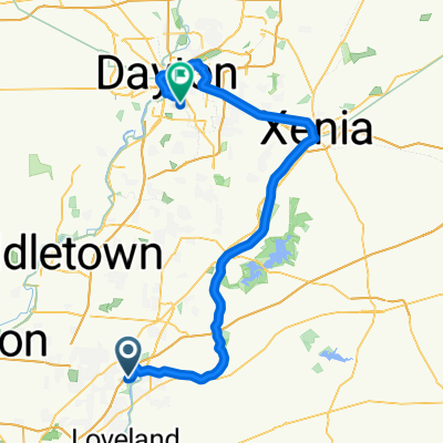
Miranda’s Icecream Route
A cycling route starting in Kings Mills, Ohio, United States.
Overview
About this route
- 1 h 6 min
- Duration
- 19.9 km
- Distance
- 141 m
- Ascent
- 138 m
- Descent
- 18.2 km/h
- Avg. speed
- ---
- Max. altitude
Continue with Bikemap
Use, edit, or download this cycling route
You would like to ride Miranda’s Icecream Route or customize it for your own trip? Here is what you can do with this Bikemap route:
Free features
- Save this route as favorite or in collections
- Copy & plan your own version of this route
- Sync your route with Garmin or Wahoo
Premium features
Free trial for 3 days, or one-time payment. More about Bikemap Premium.
- Navigate this route on iOS & Android
- Export a GPX / KML file of this route
- Create your custom printout (try it for free)
- Download this route for offline navigation
Discover more Premium features.
Get Bikemap PremiumFrom our community
Other popular routes starting in Kings Mills
- Blistering ride in Kings Mills
- Distance
- 32.5 km
- Ascent
- 213 m
- Descent
- 215 m
- Location
- Kings Mills, Ohio, United States
- Restful route in Mason
- Distance
- 5.7 km
- Ascent
- 49 m
- Descent
- 27 m
- Location
- Kings Mills, Ohio, United States
- 1731–1757 Church St, Kings Mills to 5677 Sally St, Milford
- Distance
- 25.9 km
- Ascent
- 120 m
- Descent
- 80 m
- Location
- Kings Mills, Ohio, United States
- Miranda’s Icecream Route
- Distance
- 19.9 km
- Ascent
- 141 m
- Descent
- 138 m
- Location
- Kings Mills, Ohio, United States
- 4320 Highland Green Dr, Mason to 3103 Broadstone Dr, Mason
- Distance
- 14.6 km
- Ascent
- 74 m
- Descent
- 73 m
- Location
- Kings Mills, Ohio, United States
- 1080 River Forest Dr, South Lebanon to 7837 Old 3c Highway Rd, Maineville
- Distance
- 6.1 km
- Ascent
- 6 m
- Descent
- 19 m
- Location
- Kings Mills, Ohio, United States
- 1688 Mason-Morrow-Millgrove Rd, Lebanon a Maineville
- Distance
- 14.2 km
- Ascent
- 58 m
- Descent
- 77 m
- Location
- Kings Mills, Ohio, United States
- 3029 Southfork Dr, Mason to 3200 Mason-Morrow-Millgrove Rd, Mason
- Distance
- 33.4 km
- Ascent
- 71 m
- Descent
- 69 m
- Location
- Kings Mills, Ohio, United States
Open it in the app