

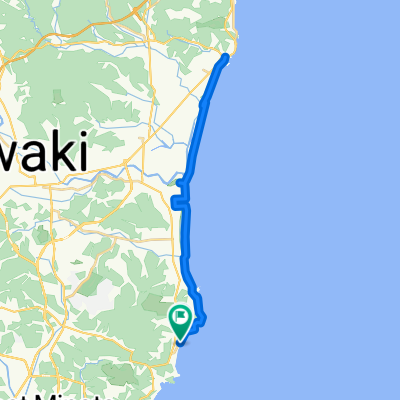
Cycle 4: Iwaki - Hitachi
A cycling route starting in Iwaki, Fukushima, Japan.
Overview
About this route
- -:--
- Duration
- 69.1 km
- Distance
- 333 m
- Ascent
- 307 m
- Descent
- ---
- Avg. speed
- ---
- Max. altitude

Route quality
Waytypes & surfaces along the route
Waytypes
Quiet road
33.9 km
(49 %)
Road
24.2 km
(35 %)
Surfaces
Paved
11.7 km
(17 %)
Asphalt
11.1 km
(16 %)
Paved (undefined)
0.7 km
(1 %)
Undefined
57.3 km
(83 %)
Continue with Bikemap
Use, edit, or download this cycling route
You would like to ride Cycle 4: Iwaki - Hitachi or customize it for your own trip? Here is what you can do with this Bikemap route:
Free features
- Save this route as favorite or in collections
- Copy & plan your own version of this route
- Sync your route with Garmin or Wahoo
Premium features
Free trial for 3 days, or one-time payment. More about Bikemap Premium.
- Navigate this route on iOS & Android
- Export a GPX / KML file of this route
- Create your custom printout (try it for free)
- Download this route for offline navigation
Discover more Premium features.
Get Bikemap PremiumFrom our community
Other popular routes starting in Iwaki
 Day - 10 Iwaki Masjid to Tsukuba Masjid (16/10/19)
- Distance
- 143.3 km
- Ascent
- 0 m
- Descent
- 0 m
- Location
- Iwaki, Fukushima, Japan
 反町, いわき市 まで3丁目, いわき市
- Distance
- 26.1 km
- Ascent
- 441 m
- Descent
- 374 m
- Location
- Iwaki, Fukushima, Japan
 泉もえぎ台3丁目14-1, いわき市 to 中野高田39, 双葉郡双葉町
- Distance
- 217.1 km
- Ascent
- 4,575 m
- Descent
- 4,596 m
- Location
- Iwaki, Fukushima, Japan
 Onigoe, Iwaki to Onigoe, Iwaki
- Distance
- 5.3 km
- Ascent
- 86 m
- Descent
- 86 m
- Location
- Iwaki, Fukushima, Japan
 県道382号, いわき市へ県道382号, いわき市
- Distance
- 17.8 km
- Ascent
- 69 m
- Descent
- 64 m
- Location
- Iwaki, Fukushima, Japan
 Cycle 4: Iwaki - Hitachi
- Distance
- 69.1 km
- Ascent
- 333 m
- Descent
- 307 m
- Location
- Iwaki, Fukushima, Japan
 県道382号, いわき市へ県道382号, いわき市
- Distance
- 34.4 km
- Ascent
- 111 m
- Descent
- 137 m
- Location
- Iwaki, Fukushima, Japan
 Iwaki-Nihonmatsu
- Distance
- 94.6 km
- Ascent
- 698 m
- Descent
- 498 m
- Location
- Iwaki, Fukushima, Japan
Open it in the app