

MFC 2010, Auf den Spuren der Römer
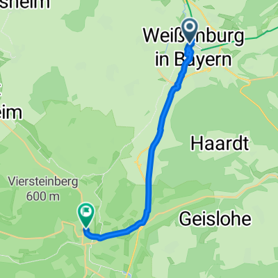
A cycling route starting in Weißenburg in Bayern, Bavaria, Germany.
Overview
About this route
The route is now newly drawn with 'track magnetization'. However, this is the route as I rode it. I must have overlooked a direction sign in Kaltenbuch and continued along the main road. I then followed the road signs to Weißenburg, and the descent down Römerstraße wasn't bad either.
- -:--
- Duration
- 125.3 km
- Distance
- 887 m
- Ascent
- 887 m
- Descent
- ---
- Avg. speed
- ---
- Max. altitude
Route quality
Waytypes & surfaces along the route
Waytypes
Road
52.6 km
(42 %)
Quiet road
50.1 km
(40 %)
Surfaces
Paved
82.7 km
(66 %)
Asphalt
82.7 km
(66 %)
Undefined
42.6 km
(34 %)
Route highlights
Points of interest along the route
Point of interest after 22.4 km
Kontrollstelle 1
Point of interest after 52.1 km
Kontrollstelle 2
Point of interest after 88.8 km
Kontrollstelle 3
Continue with Bikemap
Use, edit, or download this cycling route
You would like to ride MFC 2010, Auf den Spuren der Römer or customize it for your own trip? Here is what you can do with this Bikemap route:
Free features
- Save this route as favorite or in collections
- Copy & plan your own version of this route
- Split it into stages to create a multi-day tour
- Sync your route with Garmin or Wahoo
Premium features
Free trial for 3 days, or one-time payment. More about Bikemap Premium.
- Navigate this route on iOS & Android
- Export a GPX / KML file of this route
- Create your custom printout (try it for free)
- Download this route for offline navigation
Discover more Premium features.
Get Bikemap PremiumFrom our community
Other popular routes starting in Weißenburg in Bayern
 Ciclabile dell’Altmühl e del Danubio
- Distance
- 324.9 km
- Ascent
- 219 m
- Descent
- 325 m
- Location
- Weißenburg in Bayern, Bavaria, Germany
 Brombachsee
- Distance
- 13.2 km
- Ascent
- 176 m
- Descent
- 166 m
- Location
- Weißenburg in Bayern, Bavaria, Germany
 H 16 Weißenburg - Fossa Karolinga - Altmühlradweg bis Bf Eichstätt-Stadt
- Distance
- 55 km
- Ascent
- 452 m
- Descent
- 481 m
- Location
- Weißenburg in Bayern, Bavaria, Germany
 MFC 2010, Auf den Spuren der Römer
- Distance
- 125.3 km
- Ascent
- 887 m
- Descent
- 887 m
- Location
- Weißenburg in Bayern, Bavaria, Germany
 MidlifeCycle 2025 - Day 8 - Ride 1 - Weißenburg to Treuchtlingen
- Distance
- 13.4 km
- Ascent
- 60 m
- Descent
- 60 m
- Location
- Weißenburg in Bayern, Bavaria, Germany
 Weissenburg - Krumbach (9.Tag Stralsund - Lindau)
- Distance
- 122.5 km
- Ascent
- 554 m
- Descent
- 499 m
- Location
- Weißenburg in Bayern, Bavaria, Germany
 RTF Weissenburg 2010 137 km
- Distance
- 132.5 km
- Ascent
- 831 m
- Descent
- 832 m
- Location
- Weißenburg in Bayern, Bavaria, Germany
 Gunzenhausen - Altmühltal
- Distance
- 54.5 km
- Ascent
- 311 m
- Descent
- 312 m
- Location
- Weißenburg in Bayern, Bavaria, Germany
Open it in the app