
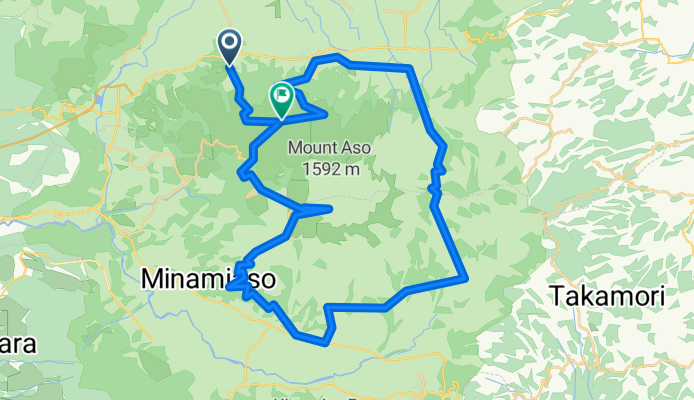
aso_day1
A cycling route starting in Aso, Kumamoto, Japan.
Overview
About this route
- -:--
- Duration
- 59.6 km
- Distance
- 1,661 m
- Ascent
- 1,339 m
- Descent
- ---
- Avg. speed
- ---
- Max. altitude

Route quality
Waytypes & surfaces along the route
Waytypes
Quiet road
25.6 km
(43 %)
Road
13.1 km
(22 %)
Surfaces
Paved
3 km
(5 %)
Asphalt
2.4 km
(4 %)
Concrete
0.6 km
(1 %)
Undefined
56.6 km
(95 %)
Continue with Bikemap
Use, edit, or download this cycling route
You would like to ride aso_day1 or customize it for your own trip? Here is what you can do with this Bikemap route:
Free features
- Save this route as favorite or in collections
- Copy & plan your own version of this route
- Sync your route with Garmin or Wahoo
Premium features
Free trial for 3 days, or one-time payment. More about Bikemap Premium.
- Navigate this route on iOS & Android
- Export a GPX / KML file of this route
- Create your custom printout (try it for free)
- Download this route for offline navigation
Discover more Premium features.
Get Bikemap PremiumFrom our community
Other popular routes starting in Aso
 aso_day1
- Distance
- 59.6 km
- Ascent
- 1,661 m
- Descent
- 1,339 m
- Location
- Aso, Kumamoto, Japan
 九州ツアー4日目
- Distance
- 93.3 km
- Ascent
- 1,399 m
- Descent
- 1,912 m
- Location
- Aso, Kumamoto, Japan
 Day 526
- Distance
- 51.2 km
- Ascent
- 572 m
- Descent
- 938 m
- Location
- Aso, Kumamoto, Japan
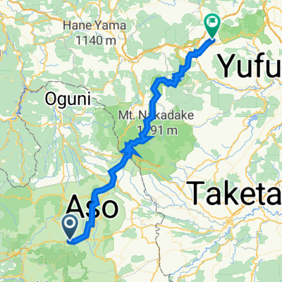
 別府一の宮線, Aso to 1483-4, Yufu
- Distance
- 115.3 km
- Ascent
- 1,241 m
- Descent
- 1,580 m
- Location
- Aso, Kumamoto, Japan
 Cracking ride
- Distance
- 163.1 km
- Ascent
- 416 m
- Descent
- 177 m
- Location
- Aso, Kumamoto, Japan
 Minami Aso-Takachiho
- Distance
- 56.3 km
- Ascent
- 964 m
- Descent
- 1,073 m
- Location
- Aso, Kumamoto, Japan
 Aso to 20-5, Yufu
- Distance
- 64.8 km
- Ascent
- 1,695 m
- Descent
- 1,769 m
- Location
- Aso, Kumamoto, Japan
 1539-2, Aso to 20-5, Yufu
- Distance
- 65 km
- Ascent
- 1,694 m
- Descent
- 1,769 m
- Location
- Aso, Kumamoto, Japan
Open it in the app