

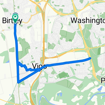
Slow ride in Gateshead and off-road
A cycling route starting in Lamesley, England, United Kingdom.
Overview
About this route
- 1 h 17 min
- Duration
- 17.7 km
- Distance
- 133 m
- Ascent
- 216 m
- Descent
- 13.7 km/h
- Avg. speed
- ---
- Max. altitude

Continue with Bikemap
Use, edit, or download this cycling route
You would like to ride Slow ride in Gateshead and off-road or customize it for your own trip? Here is what you can do with this Bikemap route:
Free features
- Save this route as favorite or in collections
- Copy & plan your own version of this route
- Sync your route with Garmin or Wahoo
Premium features
Free trial for 3 days, or one-time payment. More about Bikemap Premium.
- Navigate this route on iOS & Android
- Export a GPX / KML file of this route
- Create your custom printout (try it for free)
- Download this route for offline navigation
Discover more Premium features.
Get Bikemap PremiumFrom our community
Other popular routes starting in Lamesley
 Moderate route in Gateshead
- Distance
- 11.2 km
- Ascent
- 216 m
- Descent
- 91 m
- Location
- Lamesley, England, United Kingdom
 Pool Via Spenny 80K
- Distance
- 78.8 km
- Ascent
- 518 m
- Descent
- 668 m
- Location
- Lamesley, England, United Kingdom
 Work to Home Quickest Route
- Distance
- 15.3 km
- Ascent
- 227 m
- Descent
- 99 m
- Location
- Lamesley, England, United Kingdom
 Easy ride in
- Distance
- 38.1 km
- Ascent
- 586 m
- Descent
- 588 m
- Location
- Lamesley, England, United Kingdom
 Stamfordham Via Tyne
- Distance
- 66.9 km
- Ascent
- 353 m
- Descent
- 479 m
- Location
- Lamesley, England, United Kingdom
 morning ride
- Distance
- 11.3 km
- Ascent
- 66 m
- Descent
- 65 m
- Location
- Lamesley, England, United Kingdom
 Slow ride in Gateshead and off-road
- Distance
- 17.7 km
- Ascent
- 133 m
- Descent
- 216 m
- Location
- Lamesley, England, United Kingdom
 work > whickham > home
- Distance
- 13.9 km
- Ascent
- 269 m
- Descent
- 121 m
- Location
- Lamesley, England, United Kingdom
Open it in the app