

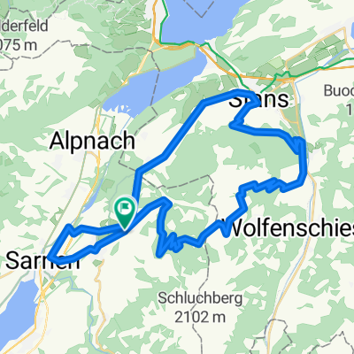
Kerns - Lungern - Flüeli - Kerns
A cycling route starting in Kerns, Canton of Obwalden, Switzerland.
Overview
About this route
- -:--
- Duration
- 35.7 km
- Distance
- 729 m
- Ascent
- 729 m
- Descent
- ---
- Avg. speed
- ---
- Max. altitude
Route quality
Waytypes & surfaces along the route
Waytypes
Quiet road
12.5 km
(35 %)
Road
8.9 km
(25 %)
Surfaces
Paved
12.5 km
(35 %)
Unpaved
3.9 km
(11 %)
Asphalt
10.7 km
(30 %)
Paved (undefined)
1.8 km
(5 %)
Continue with Bikemap
Use, edit, or download this cycling route
You would like to ride Kerns - Lungern - Flüeli - Kerns or customize it for your own trip? Here is what you can do with this Bikemap route:
Free features
- Save this route as favorite or in collections
- Copy & plan your own version of this route
- Sync your route with Garmin or Wahoo
Premium features
Free trial for 3 days, or one-time payment. More about Bikemap Premium.
- Navigate this route on iOS & Android
- Export a GPX / KML file of this route
- Create your custom printout (try it for free)
- Download this route for offline navigation
Discover more Premium features.
Get Bikemap PremiumFrom our community
Other popular routes starting in Kerns
 boro 1
- Distance
- 43.4 km
- Ascent
- 1,599 m
- Descent
- 1,642 m
- Location
- Kerns, Canton of Obwalden, Switzerland
 Kerns - Lungern - Flüeli - Kerns
- Distance
- 35.7 km
- Ascent
- 729 m
- Descent
- 729 m
- Location
- Kerns, Canton of Obwalden, Switzerland
 Kerns-Zingel-Alpnach-Kerns
- Distance
- 19.2 km
- Ascent
- 503 m
- Descent
- 504 m
- Location
- Kerns, Canton of Obwalden, Switzerland
 Kerns - Langnau i.E. (Etappe 3)
- Distance
- 63.5 km
- Ascent
- 1,516 m
- Descent
- 1,370 m
- Location
- Kerns, Canton of Obwalden, Switzerland
 Kerns - Schwandi
- Distance
- 13.5 km
- Ascent
- 523 m
- Descent
- 522 m
- Location
- Kerns, Canton of Obwalden, Switzerland
 Gemütliche Route in Kerns
- Distance
- 20.9 km
- Ascent
- 570 m
- Descent
- 578 m
- Location
- Kerns, Canton of Obwalden, Switzerland
 Swizerlands centre
- Distance
- 46.8 km
- Ascent
- 994 m
- Descent
- 1,075 m
- Location
- Kerns, Canton of Obwalden, Switzerland
 Kerns-Zingel-Alpnach-Kerns
- Distance
- 19.3 km
- Ascent
- 459 m
- Descent
- 460 m
- Location
- Kerns, Canton of Obwalden, Switzerland
Open it in the app