

MONTERIGGIONI
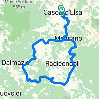
A cycling route starting in Casole d'Elsa, Tuscany, Italy.
Overview
About this route
- -:--
- Duration
- 55.9 km
- Distance
- 729 m
- Ascent
- 726 m
- Descent
- ---
- Avg. speed
- ---
- Max. altitude

Route quality
Waytypes & surfaces along the route
Waytypes
Road
27.6 km
(49 %)
Busy road
23 km
(41 %)
Surfaces
Paved
45.4 km
(81 %)
Unpaved
1.7 km
(3 %)
Asphalt
45.1 km
(81 %)
Unpaved (undefined)
0.8 km
(1 %)
Route highlights
Points of interest along the route

Point of interest after 20.7 km
Il Castello di Monteriggioni fu costruito dai senesi, per ordinanza del podestà Guelfo da Porcari, in un periodo compreso tra il 1214 e il 1219. Il terreno, acquistato dalla famiglia nobile Da Staggia, era la sede di un'antica fattoria Longobarda (la denominazione di Montis Regis probabilmente indicava un fondo di proprietà regale o che godeva di esenzioni fiscali da parte della corona).
Continue with Bikemap
Use, edit, or download this cycling route
You would like to ride MONTERIGGIONI or customize it for your own trip? Here is what you can do with this Bikemap route:
Free features
- Save this route as favorite or in collections
- Copy & plan your own version of this route
- Sync your route with Garmin or Wahoo
Premium features
Free trial for 3 days, or one-time payment. More about Bikemap Premium.
- Navigate this route on iOS & Android
- Export a GPX / KML file of this route
- Create your custom printout (try it for free)
- Download this route for offline navigation
Discover more Premium features.
Get Bikemap PremiumFrom our community
Other popular routes starting in Casole d'Elsa
 MONTERIGGIONI
- Distance
- 55.9 km
- Ascent
- 729 m
- Descent
- 726 m
- Location
- Casole d'Elsa, Tuscany, Italy
 riserva naturale berignone - volterra
- Distance
- 46.5 km
- Ascent
- 1,106 m
- Descent
- 977 m
- Location
- Casole d'Elsa, Tuscany, Italy
 San Gimignano
- Distance
- 37.6 km
- Ascent
- 801 m
- Descent
- 672 m
- Location
- Casole d'Elsa, Tuscany, Italy
 MENSANO PIEVE DI SAN GIOVANNI
- Distance
- 38.3 km
- Ascent
- 582 m
- Descent
- 578 m
- Location
- Casole d'Elsa, Tuscany, Italy
 San Gimignano
- Distance
- 37.7 km
- Ascent
- 690 m
- Descent
- 706 m
- Location
- Casole d'Elsa, Tuscany, Italy
 Casole d elsa south training route
- Distance
- 53.2 km
- Ascent
- 817 m
- Descent
- 860 m
- Location
- Casole d'Elsa, Tuscany, Italy
 Tour de Tuscany, part 1
- Distance
- 59.4 km
- Ascent
- 1,284 m
- Descent
- 1,284 m
- Location
- Casole d'Elsa, Tuscany, Italy
 Tour de Tuscany, part 2
- Distance
- 46.3 km
- Ascent
- 624 m
- Descent
- 624 m
- Location
- Casole d'Elsa, Tuscany, Italy
Open it in the app