

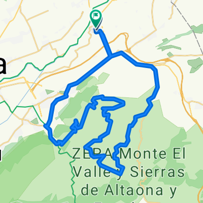
TRES EMBALSES
A cycling route starting in Beniel, Murcia, Spain.
Overview
About this route
ALQUERIAS, COBATILLAS, EMBALSE DE SANTOMERA, FORTUNA, EL FENAZAR, CAMPOTEJAR ALTA, POR VIA DE SERVICIO DIRECCION ESTACION DE BLANCA , A IZQUIERDA EN ERMITA DE SAN ROQUE, EMBALSE DE OJOS, OJOS, IZQUIERDA HACIA EL MAYES, EMBALSE DEL MAYES, TRASVASE, IZQUIERDA CTRA CEUTI, CEUTI, EN ROTONDA DE LOS PAJAROS A LA IZQUIERDA, LORQUI, EL LLANO DE MOLINA, MOLINA DE SEGURA, CABEZO CORTAO, ESPINARDO, POR AV REINO DE MURCIA, MURCIA, LA MACHACANTA, CAMINO VIEJO DE ORIHUELA, ALQUERIAS 110 KLM.
- -:--
- Duration
- 110.1 km
- Distance
- 673 m
- Ascent
- 677 m
- Descent
- ---
- Avg. speed
- ---
- Max. altitude

Route quality
Waytypes & surfaces along the route
Waytypes
Busy road
59.4 km
(54 %)
Quiet road
34.8 km
(32 %)
Surfaces
Paved
29.7 km
(27 %)
Unpaved
0.6 km
(<1 %)
Asphalt
29.1 km
(26 %)
Paved (undefined)
0.5 km
(<1 %)
Continue with Bikemap
Use, edit, or download this cycling route
You would like to ride TRES EMBALSES or customize it for your own trip? Here is what you can do with this Bikemap route:
Free features
- Save this route as favorite or in collections
- Copy & plan your own version of this route
- Split it into stages to create a multi-day tour
- Sync your route with Garmin or Wahoo
Premium features
Free trial for 3 days, or one-time payment. More about Bikemap Premium.
- Navigate this route on iOS & Android
- Export a GPX / KML file of this route
- Create your custom printout (try it for free)
- Download this route for offline navigation
Discover more Premium features.
Get Bikemap PremiumFrom our community
Other popular routes starting in Beniel
 ALQUERIAS -MALECÓN 28 MAYO
- Distance
- 19.3 km
- Ascent
- 43 m
- Descent
- 44 m
- Location
- Beniel, Murcia, Spain
 los tres perdios
- Distance
- 45.7 km
- Ascent
- 626 m
- Descent
- 629 m
- Location
- Beniel, Murcia, Spain
 alquerias, abanilla, macisvenda, el canton, cañada de la leña, fortuna, abanilla, alquerias
- Distance
- 92 km
- Ascent
- 1,183 m
- Descent
- 1,185 m
- Location
- Beniel, Murcia, Spain
 casas blancas1
- Distance
- 70.3 km
- Ascent
- 523 m
- Descent
- 524 m
- Location
- Beniel, Murcia, Spain
 ruta por la costa mediterranea
- Distance
- 111.7 km
- Ascent
- 527 m
- Descent
- 529 m
- Location
- Beniel, Murcia, Spain
 GENOVINOS-GARRUCHAL-CRESTA DEL GALLO-CRESTA-GARRUCHAL-GENOVINOS-ANTENAS DE HURCHILLO
- Distance
- 158.4 km
- Ascent
- 1,217 m
- Descent
- 1,218 m
- Location
- Beniel, Murcia, Spain
 TRES EMBALSES
- Distance
- 110.1 km
- Ascent
- 673 m
- Descent
- 677 m
- Location
- Beniel, Murcia, Spain
 SANTUARIO VIRGEN DEL ORO (ABARAN)
- Distance
- 122.4 km
- Ascent
- 601 m
- Descent
- 601 m
- Location
- Beniel, Murcia, Spain
Open it in the app