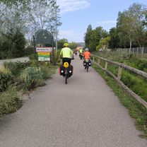
Via Rhona Groslée / La Balme-les-Grottes
A cycling route starting in Creys-Mépieu, Auvergne-Rhône-Alpes, France.
Overview
About this route
Site says 3h 27
At Lagnieu Bridge, follow the D 1075 and D 65 to join La-Balme-les-Grottes, Be careful on the road (no signposting).
- -:--
- Duration
- 51.8 km
- Distance
- 86 m
- Ascent
- 81 m
- Descent
- ---
- Avg. speed
- ---
- Max. altitude
Route quality
Waytypes & surfaces along the route
Waytypes
Quiet road
13 km
(25 %)
Cycleway
11.4 km
(22 %)
Surfaces
Paved
33.2 km
(64 %)
Unpaved
2.6 km
(5 %)
Asphalt
33.2 km
(64 %)
Gravel
2.6 km
(5 %)
Undefined
16.1 km
(31 %)
Continue with Bikemap
Use, edit, or download this cycling route
You would like to ride Via Rhona Groslée / La Balme-les-Grottes or customize it for your own trip? Here is what you can do with this Bikemap route:
Free features
- Save this route as favorite or in collections
- Copy & plan your own version of this route
- Sync your route with Garmin or Wahoo
Premium features
Free trial for 3 days, or one-time payment. More about Bikemap Premium.
- Navigate this route on iOS & Android
- Export a GPX / KML file of this route
- Create your custom printout (try it for free)
- Download this route for offline navigation
Discover more Premium features.
Get Bikemap PremiumFrom our community
Other popular routes starting in Creys-Mépieu
 Brangues to Montalieu - Ballee Bleue
- Distance
- 34.8 km
- Ascent
- 367 m
- Descent
- 401 m
- Location
- Creys-Mépieu, Auvergne-Rhône-Alpes, France
 Naar Briord
- Distance
- 25 km
- Ascent
- 660 m
- Descent
- 625 m
- Location
- Creys-Mépieu, Auvergne-Rhône-Alpes, France
 De D19 563, Groslée-Saint-Benoit à D19 563, Groslée-Saint-Benoit
- Distance
- 53.4 km
- Ascent
- 219 m
- Descent
- 273 m
- Location
- Creys-Mépieu, Auvergne-Rhône-Alpes, France
 7: ViaRhôna de Groslée à La Balme-les-Grottes
- Distance
- 51.6 km
- Ascent
- 189 m
- Descent
- 186 m
- Location
- Creys-Mépieu, Auvergne-Rhône-Alpes, France
 Via Rhona Official: Day 3
- Distance
- 99.9 km
- Ascent
- 272 m
- Descent
- 308 m
- Location
- Creys-Mépieu, Auvergne-Rhône-Alpes, France
 Ambléon au départ du col de fosses
- Distance
- 30.1 km
- Ascent
- 1,014 m
- Descent
- 1,006 m
- Location
- Creys-Mépieu, Auvergne-Rhône-Alpes, France
 TD Ain : Col Fossés - Col Portes
- Distance
- 17.6 km
- Ascent
- 451 m
- Descent
- 195 m
- Location
- Creys-Mépieu, Auvergne-Rhône-Alpes, France
 Groslee-La-Balme-les-Grottes
- Distance
- 52 km
- Ascent
- 179 m
- Descent
- 178 m
- Location
- Creys-Mépieu, Auvergne-Rhône-Alpes, France
Open it in the app


