

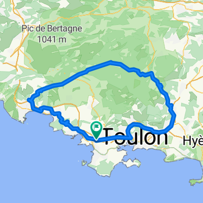
Route des crêtes
A cycling route starting in Sanary-sur-Mer, Provence-Alpes-Côte d'Azur Region, France.
Overview
About this route
- -:--
- Duration
- 90.1 km
- Distance
- 1,176 m
- Ascent
- 1,176 m
- Descent
- ---
- Avg. speed
- ---
- Max. altitude

Route quality
Waytypes & surfaces along the route
Waytypes
Road
21.6 km
(24 %)
Quiet road
8.1 km
(9 %)
Surfaces
Paved
52.2 km
(58 %)
Asphalt
49.5 km
(55 %)
Concrete
2.7 km
(3 %)
Undefined
37.8 km
(42 %)
Continue with Bikemap
Use, edit, or download this cycling route
You would like to ride Route des crêtes or customize it for your own trip? Here is what you can do with this Bikemap route:
Free features
- Save this route as favorite or in collections
- Copy & plan your own version of this route
- Split it into stages to create a multi-day tour
- Sync your route with Garmin or Wahoo
Premium features
Free trial for 3 days, or one-time payment. More about Bikemap Premium.
- Navigate this route on iOS & Android
- Export a GPX / KML file of this route
- Create your custom printout (try it for free)
- Download this route for offline navigation
Discover more Premium features.
Get Bikemap PremiumFrom our community
Other popular routes starting in Sanary-sur-Mer
 Sanary-Le Coudon
- Distance
- 26.2 km
- Ascent
- 764 m
- Descent
- 86 m
- Location
- Sanary-sur-Mer, Provence-Alpes-Côte d'Azur Region, France
 Route des crêtes
- Distance
- 90.1 km
- Ascent
- 1,176 m
- Descent
- 1,176 m
- Location
- Sanary-sur-Mer, Provence-Alpes-Côte d'Azur Region, France
 Brevet Sanary 150 km 2011 Variante RT
- Distance
- 150.8 km
- Ascent
- 1,223 m
- Descent
- 1,223 m
- Location
- Sanary-sur-Mer, Provence-Alpes-Côte d'Azur Region, France
 14.1_Le Brusc > Signes (par Col de Garde)
- Distance
- 62.6 km
- Ascent
- 943 m
- Descent
- 603 m
- Location
- Sanary-sur-Mer, Provence-Alpes-Côte d'Azur Region, France
 Faron - Mont Caume
- Distance
- 87.6 km
- Ascent
- 1,543 m
- Descent
- 1,515 m
- Location
- Sanary-sur-Mer, Provence-Alpes-Côte d'Azur Region, France
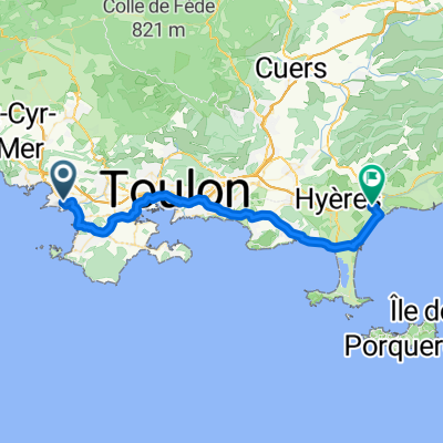
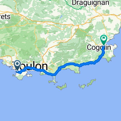 Hyères - Sainte-Maxime
- Distance
- 89.1 km
- Ascent
- 909 m
- Descent
- 919 m
- Location
- Sanary-sur-Mer, Provence-Alpes-Côte d'Azur Region, France
 DAY1 SSM to Hyeres
- Distance
- 43.3 km
- Ascent
- 252 m
- Descent
- 275 m
- Location
- Sanary-sur-Mer, Provence-Alpes-Côte d'Azur Region, France
 grand tour du camp
- Distance
- 105.2 km
- Ascent
- 1,261 m
- Descent
- 1,174 m
- Location
- Sanary-sur-Mer, Provence-Alpes-Côte d'Azur Region, France
Open it in the app