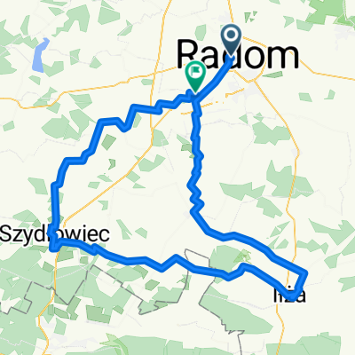
Radom 50km
A cycling route starting in Radom, Masovian Voivodeship, Poland.
Overview
About this route
- 3 h 13 min
- Duration
- 50.3 km
- Distance
- 276 m
- Ascent
- 276 m
- Descent
- 15.6 km/h
- Avg. speed
- ---
- Max. altitude
Route photos
Route quality
Waytypes & surfaces along the route
Waytypes
Road
19.5 km
(39 %)
Cycleway
9.5 km
(19 %)
Surfaces
Paved
38 km
(76 %)
Unpaved
0 km
(<1 %)
Asphalt
37.5 km
(75 %)
Paving stones
0.5 km
(1 %)
Continue with Bikemap
Use, edit, or download this cycling route
You would like to ride Radom 50km or customize it for your own trip? Here is what you can do with this Bikemap route:
Free features
- Save this route as favorite or in collections
- Copy & plan your own version of this route
- Sync your route with Garmin or Wahoo
Premium features
Free trial for 3 days, or one-time payment. More about Bikemap Premium.
- Navigate this route on iOS & Android
- Export a GPX / KML file of this route
- Create your custom printout (try it for free)
- Download this route for offline navigation
Discover more Premium features.
Get Bikemap PremiumFrom our community
Other popular routes starting in Radom
- Radom i Puszcza Kozienicka
- Distance
- 60 km
- Ascent
- 0 m
- Descent
- 0 m
- Location
- Radom, Masovian Voivodeship, Poland
- Kr贸lewskie 呕r贸d艂a
- Distance
- 76.6 km
- Ascent
- 156 m
- Descent
- 155 m
- Location
- Radom, Masovian Voivodeship, Poland
- Do Ilzy
- Distance
- 81.4 km
- Ascent
- 0 m
- Descent
- 0 m
- Location
- Radom, Masovian Voivodeship, Poland
- znakowanie
- Distance
- 13 km
- Ascent
- 52 m
- Descent
- 65 m
- Location
- Radom, Masovian Voivodeship, Poland
- Radom - Grzybowa G贸ra i powr贸t przez Skaryszew
- Distance
- 101.3 km
- Ascent
- 257 m
- Descent
- 256 m
- Location
- Radom, Masovian Voivodeship, Poland
- CoZaJazda 2025 Szyd艂owiec p臋tla hucisko
- Distance
- 57.6 km
- Ascent
- 330 m
- Descent
- 275 m
- Location
- Radom, Masovian Voivodeship, Poland
- ... setka na p贸艂noc i 3xOlszowa
- Distance
- 107.6 km
- Ascent
- 196 m
- Descent
- 196 m
- Location
- Radom, Masovian Voivodeship, Poland
- le艣na trasa
- Distance
- 61.2 km
- Ascent
- 157 m
- Descent
- 154 m
- Location
- Radom, Masovian Voivodeship, Poland
Open it in the app