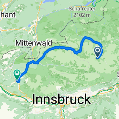
Gnadenwald- Terfens -Baumkirchen-Mils- Gnadenwald
A cycling route starting in Gnadenwald, Tyrol, Austria.
Overview
About this route
Fas alles asphaltiert
- -:--
- Duration
- 21.8 km
- Distance
- 431 m
- Ascent
- 431 m
- Descent
- ---
- Avg. speed
- ---
- Max. altitude
Continue with Bikemap
Use, edit, or download this cycling route
You would like to ride Gnadenwald- Terfens -Baumkirchen-Mils- Gnadenwald or customize it for your own trip? Here is what you can do with this Bikemap route:
Free features
- Save this route as favorite or in collections
- Copy & plan your own version of this route
- Sync your route with Garmin or Wahoo
Premium features
Free trial for 3 days, or one-time payment. More about Bikemap Premium.
- Navigate this route on iOS & Android
- Export a GPX / KML file of this route
- Create your custom printout (try it for free)
- Download this route for offline navigation
Discover more Premium features.
Get Bikemap PremiumFrom our community
Other popular routes starting in Gnadenwald
Von Hinteriss zur Falkenhütte- Distance
- 33.7 km
- Ascent
- 1,013 m
- Descent
- 1,013 m
- Location
- Gnadenwald, Tyrol, Austria
Engalm - Spitzingsee- Distance
- 84.3 km
- Ascent
- 699 m
- Descent
- 814 m
- Location
- Gnadenwald, Tyrol, Austria
Main - Alpen 9. Teil: Eng-Alm - Grainau- Distance
- 64.5 km
- Ascent
- 253 m
- Descent
- 710 m
- Location
- Gnadenwald, Tyrol, Austria
Naturpark Karwendel-Ulm- Distance
- 241.9 km
- Ascent
- 568 m
- Descent
- 1,249 m
- Location
- Gnadenwald, Tyrol, Austria
Wallgau-Eng Alm- Distance
- 37.4 km
- Ascent
- 172 m
- Descent
- 520 m
- Location
- Gnadenwald, Tyrol, Austria
3. Tag: Falken Engalm Plumsjoch Pertisau- Distance
- 21.8 km
- Ascent
- 866 m
- Descent
- 1,434 m
- Location
- Gnadenwald, Tyrol, Austria
rund wachensee and wally- Distance
- 136.7 km
- Ascent
- 638 m
- Descent
- 1,216 m
- Location
- Gnadenwald, Tyrol, Austria
Hinterhorn / Walder Alm- Distance
- 28.6 km
- Ascent
- 915 m
- Descent
- 1,081 m
- Location
- Gnadenwald, Tyrol, Austria
Open it in the app


