

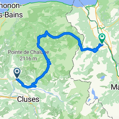
Col de la Ramaz (and above)
A cycling route starting in Mieussy, Auvergne-Rhône-Alpes, France.
Overview
About this route
Paved road up to Ramaz, then gravel higher to Col de Sommand. Much of descent was on unpaved trails.
- -:--
- Duration
- 34 km
- Distance
- 1,091 m
- Ascent
- 1,093 m
- Descent
- ---
- Avg. speed
- ---
- Max. altitude

Route highlights
Points of interest along the route
Point of interest after 17 km
Col de Sommand - 1726 metres
Point of interest after 18.4 km
Col de la Ramaz (non-geographic col) - high point of paved road - 1619 metres
Point of interest after 19.5 km
Col de la Ramaz - geographic col - 1559 metres
Continue with Bikemap
Use, edit, or download this cycling route
You would like to ride Col de la Ramaz (and above) or customize it for your own trip? Here is what you can do with this Bikemap route:
Free features
- Save this route as favorite or in collections
- Copy & plan your own version of this route
- Sync your route with Garmin or Wahoo
Premium features
Free trial for 3 days, or one-time payment. More about Bikemap Premium.
- Navigate this route on iOS & Android
- Export a GPX / KML file of this route
- Create your custom printout (try it for free)
- Download this route for offline navigation
Discover more Premium features.
Get Bikemap PremiumFrom our community
Other popular routes starting in Mieussy
 Mieussy
- Distance
- 88.1 km
- Ascent
- 1,660 m
- Descent
- 1,680 m
- Location
- Mieussy, Auvergne-Rhône-Alpes, France
 gggg
gggg- Distance
- 36.2 km
- Ascent
- 1,365 m
- Descent
- 1,540 m
- Location
- Mieussy, Auvergne-Rhône-Alpes, France
 Alpes 2008 - Day 1 of 7 (alt.)
- Distance
- 122.1 km
- Ascent
- 3,081 m
- Descent
- 2,688 m
- Location
- Mieussy, Auvergne-Rhône-Alpes, France
 Cols Ramaz, Chavan and Cordon
- Distance
- 45.8 km
- Ascent
- 1,750 m
- Descent
- 1,750 m
- Location
- Mieussy, Auvergne-Rhône-Alpes, France
 Alpen 2008. Day 1 of 7.
- Distance
- 136.1 km
- Ascent
- 3,431 m
- Descent
- 3,126 m
- Location
- Mieussy, Auvergne-Rhône-Alpes, France
 Ramaz-Joux-Plane
- Distance
- 76.4 km
- Ascent
- 2,009 m
- Descent
- 2,009 m
- Location
- Mieussy, Auvergne-Rhône-Alpes, France
 Mieussy 3 cols
- Distance
- 76.9 km
- Ascent
- 2,008 m
- Descent
- 2,028 m
- Location
- Mieussy, Auvergne-Rhône-Alpes, France
 Mieussy - Monthey
- Distance
- 81.5 km
- Ascent
- 1,527 m
- Descent
- 1,768 m
- Location
- Mieussy, Auvergne-Rhône-Alpes, France
Open it in the app