

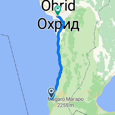
Магаро 2255 м.н.в
A cycling route starting in Ohrid, Ohrid, North Macedonia.
Overview
About this route
Планинарска тура која се наоѓа на Национален парк Галичица со преубава природа и поглед на Преспанско и Охридско езеро.
- -:--
- Duration
- 8.5 km
- Distance
- 683 m
- Ascent
- 682 m
- Descent
- ---
- Avg. speed
- ---
- Max. altitude

Continue with Bikemap
Use, edit, or download this cycling route
You would like to ride Магаро 2255 м.н.в or customize it for your own trip? Here is what you can do with this Bikemap route:
Free features
- Save this route as favorite or in collections
- Copy & plan your own version of this route
- Sync your route with Garmin or Wahoo
Premium features
Free trial for 3 days, or one-time payment. More about Bikemap Premium.
- Navigate this route on iOS & Android
- Export a GPX / KML file of this route
- Create your custom printout (try it for free)
- Download this route for offline navigation
Discover more Premium features.
Get Bikemap PremiumFrom our community
Other popular routes starting in Ohrid
 Velestovo trail
- Distance
- 9.3 km
- Ascent
- 300 m
- Descent
- 676 m
- Location
- Ohrid, Ohrid, North Macedonia
 Велестово Gorno Konjsko Galic
- Distance
- 13.8 km
- Ascent
- 512 m
- Descent
- 317 m
- Location
- Ohrid, Ohrid, North Macedonia
 Velestovo - Asan Dzura (Djura-Gjura-Gura) to Dame Gruev 106, Ohrid
- Distance
- 24.6 km
- Ascent
- 752 m
- Descent
- 1,221 m
- Location
- Ohrid, Ohrid, North Macedonia
 Ohrid - Konjsko
- Distance
- 16.4 km
- Ascent
- 519 m
- Descent
- 526 m
- Location
- Ohrid, Ohrid, North Macedonia
 Галичица*
- Distance
- 64.1 km
- Ascent
- 1,227 m
- Descent
- 1,228 m
- Location
- Ohrid, Ohrid, North Macedonia
 Restful route
- Distance
- 20.1 km
- Ascent
- 170 m
- Descent
- 257 m
- Location
- Ohrid, Ohrid, North Macedonia
 Rund um den Ohridsee
- Distance
- 107.1 km
- Ascent
- 962 m
- Descent
- 960 m
- Location
- Ohrid, Ohrid, North Macedonia
 gal 3
gal 3- Distance
- 32.8 km
- Ascent
- 955 m
- Descent
- 953 m
- Location
- Ohrid, Ohrid, North Macedonia
Open it in the app