

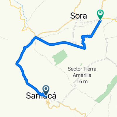
Etapa 2 - Muysca Bike Challenge
A cycling route starting in Samacá, Departamento de Boyacá, Colombia.
Overview
About this route
Second Stage Competitive Categories of the Muysca Bike Challenge 2019
Boyacá Bridge - Vargas Swamp
- -:--
- Duration
- 100.2 km
- Distance
- 2,093 m
- Ascent
- 2,292 m
- Descent
- ---
- Avg. speed
- ---
- Max. altitude

Continue with Bikemap
Use, edit, or download this cycling route
You would like to ride Etapa 2 - Muysca Bike Challenge or customize it for your own trip? Here is what you can do with this Bikemap route:
Free features
- Save this route as favorite or in collections
- Copy & plan your own version of this route
- Split it into stages to create a multi-day tour
- Sync your route with Garmin or Wahoo
Premium features
Free trial for 3 days, or one-time payment. More about Bikemap Premium.
- Navigate this route on iOS & Android
- Export a GPX / KML file of this route
- Create your custom printout (try it for free)
- Download this route for offline navigation
Discover more Premium features.
Get Bikemap PremiumFrom our community
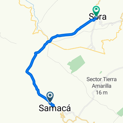
Other popular routes starting in Samacá
 Etapa 2 - Muysca Bike Challenge
- Distance
- 100.2 km
- Ascent
- 2,093 m
- Descent
- 2,292 m
- Location
- Samacá, Departamento de Boyacá, Colombia
 Etapa 5 - 36a Vuelta a Boyacá 2014
- Distance
- 34.5 km
- Ascent
- 643 m
- Descent
- 465 m
- Location
- Samacá, Departamento de Boyacá, Colombia
 De Autopista Norte, Boyacá a Vía a Samaca, Samacá
- Distance
- 10.1 km
- Ascent
- 192 m
- Descent
- 315 m
- Location
- Samacá, Departamento de Boyacá, Colombia
 Samacá Cycling
- Distance
- 27.3 km
- Ascent
- 244 m
- Descent
- 709 m
- Location
- Samacá, Departamento de Boyacá, Colombia
 primer dia
- Distance
- 19.3 km
- Ascent
- 472 m
- Descent
- 89 m
- Location
- Samacá, Departamento de Boyacá, Colombia
 De Bogotá - Tunja a Carrera 13 11-83, Villa de Leyva
- Distance
- 35.4 km
- Ascent
- 460 m
- Descent
- 1,103 m
- Location
- Samacá, Departamento de Boyacá, Colombia
 De FGX5+HW a Carrera 3ª # 3-73
- Distance
- 13.8 km
- Ascent
- 126 m
- Descent
- 48 m
- Location
- Samacá, Departamento de Boyacá, Colombia
 Samacá, Samaca a Samacá, Samaca
- Distance
- 0.6 km
- Ascent
- 43 m
- Descent
- 0 m
- Location
- Samacá, Departamento de Boyacá, Colombia
Open it in the app