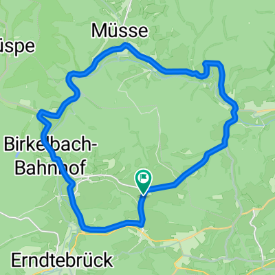
Große Feudinger 8
A cycling route starting in Erndtebrück, North Rhine-Westphalia, Germany.
Overview
About this route
Ilsetal-Banfe-Fischelbach-Oberdieten-Simmersbach-Niedereisenhausen-Breidenbach-Perftalsperre-Niederlaasphe-Radweg Laasphe+Banfe-Heiligenborn-Siegquelle-Benfe-Erndtebrück-Dille-Leimstruth-Saßmannshausen
- -:--
- Duration
- 94.6 km
- Distance
- 815 m
- Ascent
- 816 m
- Descent
- ---
- Avg. speed
- ---
- Avg. speed
Route quality
Waytypes & surfaces along the route
Waytypes
Road
34.6 km
(37 %)
Busy road
29.6 km
(31 %)
Surfaces
Paved
59.1 km
(63 %)
Asphalt
53 km
(56 %)
Paved (undefined)
5.4 km
(6 %)
Continue with Bikemap
Use, edit, or download this cycling route
You would like to ride Große Feudinger 8 or customize it for your own trip? Here is what you can do with this Bikemap route:
Free features
- Save this route as favorite or in collections
- Copy & plan your own version of this route
- Sync your route with Garmin or Wahoo
Premium features
Free trial for 3 days, or one-time payment. More about Bikemap Premium.
- Navigate this route on iOS & Android
- Export a GPX / KML file of this route
- Create your custom printout (try it for free)
- Download this route for offline navigation
Discover more Premium features.
Get Bikemap PremiumFrom our community
Other popular routes starting in Erndtebrück
- Lahntal-Radweg
- Distance
- 245.8 km
- Ascent
- 235 m
- Descent
- 781 m
- Location
- Erndtebrück, North Rhine-Westphalia, Germany
- Rund um den Dreiherrenstein
- Distance
- 62.2 km
- Ascent
- 785 m
- Descent
- 788 m
- Location
- Erndtebrück, North Rhine-Westphalia, Germany
- Lahn 2014
- Distance
- 217.3 km
- Ascent
- 2,614 m
- Descent
- 3,025 m
- Location
- Erndtebrück, North Rhine-Westphalia, Germany
- lLahnradweg neu 22.03.2019
- Distance
- 194.1 km
- Ascent
- 721 m
- Descent
- 1,255 m
- Location
- Erndtebrück, North Rhine-Westphalia, Germany
- lahntal feudingen-koblenz
- Distance
- 250.8 km
- Ascent
- 2,199 m
- Descent
- 2,514 m
- Location
- Erndtebrück, North Rhine-Westphalia, Germany
- Lahnradweg ca. 268 km, Gesamttour
- Distance
- 267.2 km
- Ascent
- 1,936 m
- Descent
- 2,476 m
- Location
- Erndtebrück, North Rhine-Westphalia, Germany
- Ilsetal-Edertal-R8-Perftalsee-Banfetal
- Distance
- 100.9 km
- Ascent
- 751 m
- Descent
- 750 m
- Location
- Erndtebrück, North Rhine-Westphalia, Germany
- Ilsetal-Fischelbach-Dietzhölztal-Hainchen-Deutz-Siegquelle-Benfe-Leimstruth
- Distance
- 76.7 km
- Ascent
- 851 m
- Descent
- 855 m
- Location
- Erndtebrück, North Rhine-Westphalia, Germany
Open it in the app