

scorgnan
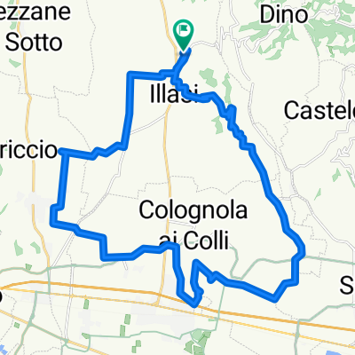
A cycling route starting in Illasi, Veneto, Italy.
Overview
About this route
- 1 h 52 min
- Duration
- 27.6 km
- Distance
- 497 m
- Ascent
- 499 m
- Descent
- 14.8 km/h
- Avg. speed
- ---
- Max. altitude

Route quality
Waytypes & surfaces along the route
Waytypes
Quiet road
15.7 km
(57 %)
Road
4.1 km
(15 %)
Surfaces
Paved
19.6 km
(71 %)
Asphalt
19.6 km
(71 %)
Undefined
8 km
(29 %)
Continue with Bikemap
Use, edit, or download this cycling route
You would like to ride scorgnan or customize it for your own trip? Here is what you can do with this Bikemap route:
Free features
- Save this route as favorite or in collections
- Copy & plan your own version of this route
- Sync your route with Garmin or Wahoo
Premium features
Free trial for 3 days, or one-time payment. More about Bikemap Premium.
- Navigate this route on iOS & Android
- Export a GPX / KML file of this route
- Create your custom printout (try it for free)
- Download this route for offline navigation
Discover more Premium features.
Get Bikemap PremiumFrom our community
Other popular routes starting in Illasi
 Percorso moderato in Illasi
- Distance
- 29 km
- Ascent
- 336 m
- Descent
- 337 m
- Location
- Illasi, Veneto, Italy
 Giro a velocità costante in Illasi
- Distance
- 29.9 km
- Ascent
- 319 m
- Descent
- 317 m
- Location
- Illasi, Veneto, Italy
 Illasi - Capovilla - B.Calavena - Collina
- Distance
- 37.6 km
- Ascent
- 829 m
- Descent
- 829 m
- Location
- Illasi, Veneto, Italy
 Easy ride in Illasi
- Distance
- 4.1 km
- Ascent
- 4 m
- Descent
- 34 m
- Location
- Illasi, Veneto, Italy
 Piero's trail
- Distance
- 34.9 km
- Ascent
- 1,354 m
- Descent
- 1,273 m
- Location
- Illasi, Veneto, Italy
 Percorso moderato in Illasi
- Distance
- 27.6 km
- Ascent
- 570 m
- Descent
- 571 m
- Location
- Illasi, Veneto, Italy
 Tregnago-SGI
- Distance
- 39.6 km
- Ascent
- 1,011 m
- Descent
- 1,016 m
- Location
- Illasi, Veneto, Italy
 illasi d'intorni
- Distance
- 15.9 km
- Ascent
- 248 m
- Descent
- 316 m
- Location
- Illasi, Veneto, Italy
Open it in the app