

07. Bad Tölz - Miesbach - Schliersee - Bayrischzell
A cycling route starting in Bad Tölz, Bavaria, Germany.
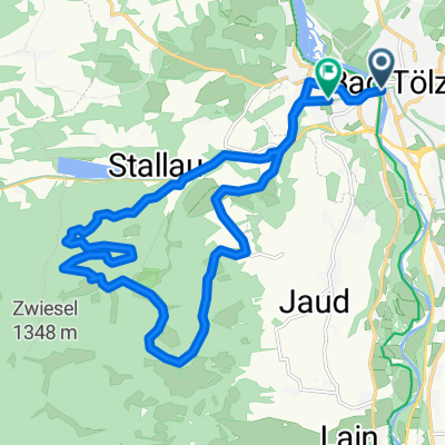
Overview
About this route
- Juli 2019: Zürich-Regensburg (Etappe 7).
Bild: Schliersee
Achtung: Faktisch unpassierbarer Passage mit verbotenem Bahnübergang hinter Oberadarching.
- -:--
- Duration
- 60.6 km
- Distance
- 332 m
- Ascent
- 215 m
- Descent
- ---
- Avg. speed
- ---
- Max. altitude

Route quality
Waytypes & surfaces along the route
Waytypes
Quiet road
23.5 km
(39 %)
Road
12.1 km
(20 %)
Surfaces
Paved
48.3 km
(80 %)
Unpaved
10.4 km
(17 %)
Asphalt
47.5 km
(78 %)
Loose gravel
4 km
(7 %)
Continue with Bikemap
Use, edit, or download this cycling route
You would like to ride 07. Bad Tölz - Miesbach - Schliersee - Bayrischzell or customize it for your own trip? Here is what you can do with this Bikemap route:
Free features
- Save this route as favorite or in collections
- Copy & plan your own version of this route
- Sync your route with Garmin or Wahoo
Premium features
Free trial for 3 days, or one-time payment. More about Bikemap Premium.
- Navigate this route on iOS & Android
- Export a GPX / KML file of this route
- Create your custom printout (try it for free)
- Download this route for offline navigation
Discover more Premium features.
Get Bikemap PremiumFrom our community
Other popular routes starting in Bad Tölz
 Runde um Brauneck/Benediktenwand
- Distance
- 75.4 km
- Ascent
- 1,416 m
- Descent
- 1,416 m
- Location
- Bad Tölz, Bavaria, Germany
 Blomberg
- Distance
- 18.2 km
- Ascent
- 626 m
- Descent
- 614 m
- Location
- Bad Tölz, Bavaria, Germany
 Bad Tölz - München
- Distance
- 60.9 km
- Ascent
- 440 m
- Descent
- 574 m
- Location
- Bad Tölz, Bavaria, Germany
 Eichmühlstraße, Bad Tölz nach Lengries über Felder, Wiesen und Bauernhöfe zurück
- Distance
- 38.4 km
- Ascent
- 690 m
- Descent
- 696 m
- Location
- Bad Tölz, Bavaria, Germany
 Bad Tölz - Walchensee - Lenggries
- Distance
- 72.3 km
- Ascent
- 611 m
- Descent
- 611 m
- Location
- Bad Tölz, Bavaria, Germany
 Wengleinstraße 20, Bad Tölz nach Am Bichlerhof 3, Bad Tölz
- Distance
- 31.1 km
- Ascent
- 361 m
- Descent
- 353 m
- Location
- Bad Tölz, Bavaria, Germany
 Tölz-Kochel-Einsiedln-Jachenau-Lenggries-Tölz
- Distance
- 80.7 km
- Ascent
- 1,202 m
- Descent
- 1,153 m
- Location
- Bad Tölz, Bavaria, Germany
 München - Walchensee - München
- Distance
- 101.2 km
- Ascent
- 1,142 m
- Descent
- 1,081 m
- Location
- Bad Tölz, Bavaria, Germany
Open it in the app