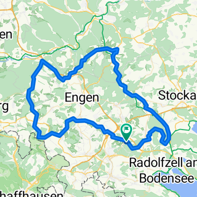
Hegau Runde 100km
- 93.9 km
- 798 m
- 798 m
- Volkertshausen, Baden-Wurttemberg, Germany
A cycling route starting in Volkertshausen, Baden-Wurttemberg, Germany.
Overview
Start in Volkertshausen at the corner of Wald-/Börisriedstr., then head towards Langenstein. After 2.6 km, just before the pond, turn right onto a dirt path, a short climb up to the country road. Before the motorway, turn left and continue parallel to the motorway until the district road Steisslingen-Orsingen. Cross this road and follow parallel towards Steisslingen. Then climb to the highest point just over 600 m. Afterwards, a fast descent on a gravel track (caution: over 45 km/h). Then a sharp right turn and back again. This loop can be ridden multiple times. Return leisurely via Schoren to Volkertshausen. Have fun!
created this 15 years ago
Route quality
Track
11 km
(57 %)
Road
4.4 km
(23 %)
Paved
11.4 km
(59 %)
Unpaved
5.2 km
(27 %)
Asphalt
9.3 km
(48 %)
Gravel
3.5 km
(18 %)
Continue with Bikemap
You would like to ride Kurze MTB Strecke Kirnberg or customize it for your own trip? Here is what you can do with this Bikemap route:
Free trial for 3 days, or one-time payment. More about Bikemap Premium.
Discover more Premium features.
Get Bikemap PremiumFrom our community
Open it in the app