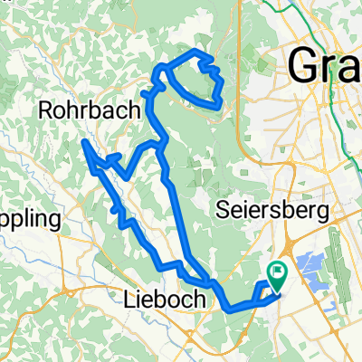
IM70.30.Graz_Bike
A cycling route starting in Unterpremstätten, Styria, Austria.
Overview
About this route
Projektion Radroute Ironman 70.30 für(ab) 24.05.2020 in Graz
- -:--
- Duration
- 91.8 km
- Distance
- 508 m
- Ascent
- 468 m
- Descent
- ---
- Avg. speed
- ---
- Avg. speed
Route quality
Waytypes & surfaces along the route
Waytypes
Busy road
63.7 km
(69 %)
Cycleway
9 km
(10 %)
Surfaces
Paved
68.7 km
(75 %)
Unpaved
0.3 km
(<1 %)
Asphalt
67.9 km
(74 %)
Paved (undefined)
0.8 km
(<1 %)
Route highlights
Points of interest along the route
Point of interest after 31.4 km
Absperrung
Point of interest after 79.3 km
nur Einkaufszentrum zufahrt
Point of interest after 80.4 km
Frage ob Schranke (Durchfahrt möglich?)
Point of interest after 82.9 km
Radwegauffahrt (rechts, ~ 300m)
Point of interest after 83.3 km
300m Radweg auf rechter Seite um autobahnabfahrt nicht zu behindern
Point of interest after 83.6 km
Radwegunterführung unter Autobahnabfahrt
Point of interest after 86.9 km
GAK Fußball (ggf. Spiel checken!)
Point of interest after 86.9 km
Kreuzung
Point of interest after 88.8 km
Kreuzung
Point of interest after 89.3 km
Kreuzung
Bike service after 90.3 km
Point of interest after 90.7 km
Bike service after 91.4 km
Point of interest after 91.5 km
Keuzung
Continue with Bikemap
Use, edit, or download this cycling route
You would like to ride IM70.30.Graz_Bike or customize it for your own trip? Here is what you can do with this Bikemap route:
Free features
- Save this route as favorite or in collections
- Copy & plan your own version of this route
- Sync your route with Garmin or Wahoo
Premium features
Free trial for 3 days, or one-time payment. More about Bikemap Premium.
- Navigate this route on iOS & Android
- Export a GPX / KML file of this route
- Create your custom printout (try it for free)
- Download this route for offline navigation
Discover more Premium features.
Get Bikemap PremiumFrom our community
Other popular routes starting in Unterpremstätten
- Schwarzlsee - Wildon - Kirchberg - St. Margarethen - Nestelbach - Schwarzlsee
- Distance
- 88.4 km
- Ascent
- 946 m
- Descent
- 953 m
- Location
- Unterpremstätten, Styria, Austria
- Steiermark 2 - Westl. Steiermark
- Distance
- 56.4 km
- Ascent
- 528 m
- Descent
- 528 m
- Location
- Unterpremstätten, Styria, Austria
- Kalsdorf - Muttendorf - Dobl - Unterpremstätten
- Distance
- 46.9 km
- Ascent
- 239 m
- Descent
- 249 m
- Location
- Unterpremstätten, Styria, Austria
- Unterpremstätten-Wetzelsdorf-Preding-Lamberg-Steindorf-Wundschuh-Unterpremstätten
- Distance
- 44.4 km
- Ascent
- 0 m
- Descent
- 0 m
- Location
- Unterpremstätten, Styria, Austria
- schwarzlsee-wundschuh-gantschenberg-preding-tobisegg-dobl-unterpremstätten
- Distance
- 37 km
- Ascent
- 346 m
- Descent
- 349 m
- Location
- Unterpremstätten, Styria, Austria
- Über die süd-westl Hügeln
- Distance
- 54 km
- Ascent
- 564 m
- Descent
- 564 m
- Location
- Unterpremstätten, Styria, Austria
- Glocknerman 2014
- Distance
- 1,054.8 km
- Ascent
- 7,201 m
- Descent
- 7,201 m
- Location
- Unterpremstätten, Styria, Austria
- Die Südrunde
- Distance
- 55.7 km
- Ascent
- 159 m
- Descent
- 159 m
- Location
- Unterpremstätten, Styria, Austria