

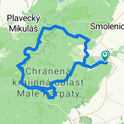
Karpathian Trail 3
A cycling route starting in Smolenice, Trnava Region, Slovakia.
Overview
About this route
- -:--
- Duration
- 74.3 km
- Distance
- 179 m
- Ascent
- 187 m
- Descent
- ---
- Avg. speed
- ---
- Max. altitude

Route quality
Waytypes & surfaces along the route
Waytypes
Quiet road
8.2 km
(11 %)
Road
4.5 km
(6 %)
Surfaces
Paved
39.4 km
(53 %)
Unpaved
3 km
(4 %)
Asphalt
39.4 km
(53 %)
Ground
3 km
(4 %)
Undefined
31.9 km
(43 %)
Continue with Bikemap
Use, edit, or download this cycling route
You would like to ride Karpathian Trail 3 or customize it for your own trip? Here is what you can do with this Bikemap route:
Free features
- Save this route as favorite or in collections
- Copy & plan your own version of this route
- Sync your route with Garmin or Wahoo
Premium features
Free trial for 3 days, or one-time payment. More about Bikemap Premium.
- Navigate this route on iOS & Android
- Export a GPX / KML file of this route
- Create your custom printout (try it for free)
- Download this route for offline navigation
Discover more Premium features.
Get Bikemap PremiumFrom our community
Other popular routes starting in Smolenice
 do školy ....ale len tak
- Distance
- 41.7 km
- Ascent
- 263 m
- Descent
- 267 m
- Location
- Smolenice, Trnava Region, Slovakia
 Boleraz Bohdanovce(Dolna Krupa)
- Distance
- 29.2 km
- Ascent
- 181 m
- Descent
- 184 m
- Location
- Smolenice, Trnava Region, Slovakia
 Jahodník - Plavecký Mikuláš - Čertova skala - Jahodník.
- Distance
- 19.9 km
- Ascent
- 598 m
- Descent
- 602 m
- Location
- Smolenice, Trnava Region, Slovakia
 malé karpaty
- Distance
- 48.7 km
- Ascent
- 1,502 m
- Descent
- 1,493 m
- Location
- Smolenice, Trnava Region, Slovakia
 48.505, 17.318 až 48.506, 17.316
- Distance
- 14.3 km
- Ascent
- 369 m
- Descent
- 377 m
- Location
- Smolenice, Trnava Region, Slovakia
 Malé Karpaty - Vápenná, Klokoč, Báborská,
- Distance
- 13.8 km
- Ascent
- 609 m
- Descent
- 609 m
- Location
- Smolenice, Trnava Region, Slovakia
 Horný Chríb 32A do Horný Chríb 32A
- Distance
- 32.2 km
- Ascent
- 442 m
- Descent
- 488 m
- Location
- Smolenice, Trnava Region, Slovakia
 Prievaly - Šenkvice
- Distance
- 56.2 km
- Ascent
- 1,787 m
- Descent
- 1,868 m
- Location
- Smolenice, Trnava Region, Slovakia
Open it in the app