
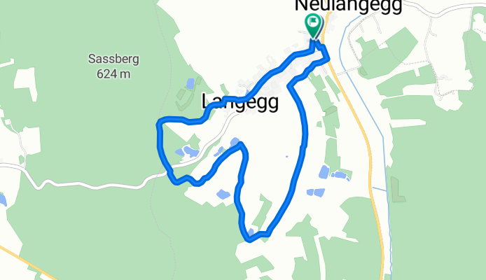
Wandertag 2019
A cycling route starting in Schrems, Lower Austria, Austria.
Overview
About this route
- -:--
- Duration
- 4.7 km
- Distance
- 94 m
- Ascent
- 93 m
- Descent
- ---
- Avg. speed
- ---
- Max. altitude
Route highlights
Points of interest along the route
Point of interest after 0.8 km
Mohnnudeln
Point of interest after 2.3 km
Raststation 1
Point of interest after 3.6 km
Raststation 2
Continue with Bikemap
Use, edit, or download this cycling route
You would like to ride Wandertag 2019 or customize it for your own trip? Here is what you can do with this Bikemap route:
Free features
- Save this route as favorite or in collections
- Copy & plan your own version of this route
- Sync your route with Garmin or Wahoo
Premium features
Free trial for 3 days, or one-time payment. More about Bikemap Premium.
- Navigate this route on iOS & Android
- Export a GPX / KML file of this route
- Create your custom printout (try it for free)
- Download this route for offline navigation
Discover more Premium features.
Get Bikemap PremiumFrom our community
Other popular routes starting in Schrems
 Schrems-Ludwigsthal
- Distance
- 16 km
- Ascent
- 205 m
- Descent
- 225 m
- Location
- Schrems, Lower Austria, Austria
 Schrems - Brand - Schrems - abseits der Straße
- Distance
- 22.2 km
- Ascent
- 228 m
- Descent
- 232 m
- Location
- Schrems, Lower Austria, Austria
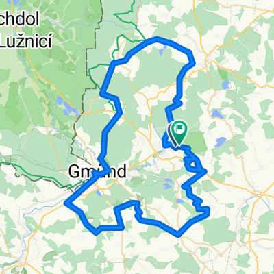
 Langegg - Litschau - Langegg
- Distance
- 42.5 km
- Ascent
- 422 m
- Descent
- 432 m
- Location
- Schrems, Lower Austria, Austria
 Wasserlandschaftsradweg
- Distance
- 89.1 km
- Ascent
- 883 m
- Descent
- 883 m
- Location
- Schrems, Lower Austria, Austria
 Wandertag 2022
- Distance
- 5 km
- Ascent
- 51 m
- Descent
- 50 m
- Location
- Schrems, Lower Austria, Austria
 Wandertag 2019
- Distance
- 4.7 km
- Ascent
- 94 m
- Descent
- 93 m
- Location
- Schrems, Lower Austria, Austria
 Waldviertler Wasserlandschaftsradweg
- Distance
- 76.4 km
- Ascent
- 759 m
- Descent
- 760 m
- Location
- Schrems, Lower Austria, Austria
 Waldviertel: Wasserlandschaftsradweg
- Distance
- 108.7 km
- Ascent
- 753 m
- Descent
- 753 m
- Location
- Schrems, Lower Austria, Austria
Open it in the app